


The West Santa Ana Branch light rail would offer new infrastructure and economic activity to a transit-dependent part of the county.
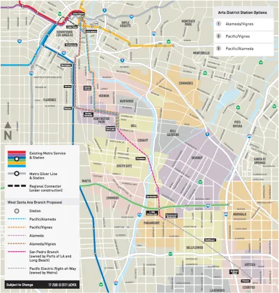
Named for an old Pacific Electric line, the West Santa Ana Branch Transit Corridor would take one of four possible routes spanning about 20 miles from Artesia to Downtown L.A.'s Union Station. With a projected ridership of at least 80,000, it would be one of the busiest light rail lines in the country.
Twelve cities, plus the Hollywood-Burbank Airport, are managing the project through a JPA called Eco-Rapid Transit, headed by transportation planner Michael Kodama. In The Planning Report, Kodama explains the JPA's holistic view of the rail line as a mechanism to bolster economic development and connectivity along the length of the corridor, noting the opportunity to fill other infrastructure gaps in the project area.
"This project serves an area of Los Angeles County that is, frankly, underserved," he says. "It goes through the industrial and manufacturing heart of the county, where a lot of folks don’t have high incomes and have big transit needs."
Metro's Office of Extraordinary Innovation recently greenlit an unsolicited proposal for a public-private partnership that could condense the entire project into one phase. It would be the first P3 of its kind in L.A., Kodama says. He speaks more about funding, equity, and the economic impacts of the project in TPR.
FULL STORY: Eco-Rapid Transit: Metro Light Rail to Connect Southeast County & DTLA

$4.3 Billion Awarded to California Transformative Projects from Gas Tax and Climate Fund
Two difficult votes last year, both requiring super-majorities, are paying huge dividends to 28 transformative projects throughout the Golden State to improve rail and transit service and reduce greenhouse gas emissions.

L.A. Metro CEO Challenges Trump on Infrastructure Funding
President Trump’s most recent transportation budget is projected to cut transportation spending by 13 percent, potentially undercutting many of Los Angeles' ambitious projects to continue the build-out of a full public transportation system.
Auto Companies Prepare for Decline of Car Ownership
It's no longer just transit agencies that are trying to meet the first mile-last mile challenge—auto companies have also jumped in by offering "mobility services." And it's more profitable than selling cars!

National Parks Layoffs Will Cause Communities to Lose Billions
Thousands of essential park workers were laid off this week, just before the busy spring break season.

Retro-silient?: America’s First “Eco-burb,” The Woodlands Turns 50
A master-planned community north of Houston offers lessons on green infrastructure and resilient design, but falls short of its founder’s lofty affordability and walkability goals.

Delivering for America Plan Will Downgrade Mail Service in at Least 49.5 Percent of Zip Codes
Republican and Democrat lawmakers criticize the plan for its disproportionate negative impact on rural communities.

Test News Post 1
This is a summary

Test News Headline 46
Test for the image on the front page.

Balancing Bombs and Butterflies: How the National Guard Protects a Rare Species
The National Guard at Fort Indiantown Gap uses GIS technology and land management strategies to balance military training with conservation efforts, ensuring the survival of the rare eastern regal fritillary butterfly.
Urban Design for Planners 1: Software Tools
This six-course series explores essential urban design concepts using open source software and equips planners with the tools they need to participate fully in the urban design process.
Planning for Universal Design
Learn the tools for implementing Universal Design in planning regulations.
EMC Planning Group, Inc.
Planetizen
Planetizen
Mpact (formerly Rail~Volution)
Great Falls Development Authority, Inc.
HUDs Office of Policy Development and Research
NYU Wagner Graduate School of Public Service