


The city hopes to accelerate development and mitigate flood risk along the industrial Fort Point Channel with a string of new parks.

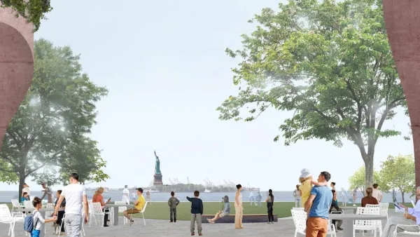
Mayor Martin Walsh and the Trustees of Reservations have released plans for a network of parks along the Fort Point Channel, which they hope will both attract investment to the industrial corridor and mitigate the impacts of sea-level rise on its low-lying neighborhoods.
The channel runs from Boston Harbor to the railyard between South Boston and the South End, and is "one of the hottest pockets in Boston's real estate market," according to the Boston Globe. Conceptual designs call for connecting the parks through pedestrian bridges and artificial islands, bringing a string of green space to an area that is anticipating both major new development—from Amazon and GE—and increasing flood risk.
A recently issued report, “Climate Ready Boston,” identified Fort Point Channel as a throughway that could allow water to inundate low-lying areas of the South End and Roxbury. Shoring it up — by changing the topography, installing water-absorbing marshlands, and giving water someplace to flow safely — could have great benefits.
Those benefits would extend from Fort Point to the downtown area, Chinatown, and South Boston, according to the mayor.
FULL STORY: Park plan envisions fun — and flood control — along Fort Point


Cities Turn to Highway Cap Parks for Economic Development
Some worry that, of the many reasons cities pursue cap parks, creating quality green space is low on the list.
Battery Park Resilience Project Breaks Ground
By 2027, the shoreline will be elevated by 5 feet to prevent flooding from future storm surges.

Making California State Parks More Climate-Resilient
A recently released report offers recommendations for keeping state parks healthy and robust, including acquiring additional land for conservation and recreation.

National Parks Layoffs Will Cause Communities to Lose Billions
Thousands of essential park workers were laid off this week, just before the busy spring break season.

Retro-silient?: America’s First “Eco-burb,” The Woodlands Turns 50
A master-planned community north of Houston offers lessons on green infrastructure and resilient design, but falls short of its founder’s lofty affordability and walkability goals.

Delivering for America Plan Will Downgrade Mail Service in at Least 49.5 Percent of Zip Codes
Republican and Democrat lawmakers criticize the plan for its disproportionate negative impact on rural communities.

Test News Post 1
This is a summary

Test News Headline 46
Test for the image on the front page.

Balancing Bombs and Butterflies: How the National Guard Protects a Rare Species
The National Guard at Fort Indiantown Gap uses GIS technology and land management strategies to balance military training with conservation efforts, ensuring the survival of the rare eastern regal fritillary butterfly.
Urban Design for Planners 1: Software Tools
This six-course series explores essential urban design concepts using open source software and equips planners with the tools they need to participate fully in the urban design process.
Planning for Universal Design
Learn the tools for implementing Universal Design in planning regulations.
EMC Planning Group, Inc.
Planetizen
Planetizen
Mpact (formerly Rail~Volution)
Great Falls Development Authority, Inc.
HUDs Office of Policy Development and Research
NYU Wagner Graduate School of Public Service