


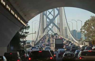
It is now up to the Bay Area's transportation planning agency to determine when to ask voters to hike tolls on seven Bay Area bridges, by how much, and whether to phase the increase. A bill to allow voters to fund Caltrain was also signed.
"The Metropolitan Transportation Commission [MTC] will decide early in 2018 on the logistics of Regional Measure 3 [RM 3], which would require an overall majority vote in the nine Bay Area counties to become law," reports Michael Cabanatuan for the San Francisco Chronicle.
If voters go along with it, the toll increases would cover all of the Bay Area’s state-owned bridges but would exclude the Golden Gate Bridge, which is independently owned and sets its own tolls.
What is clear, however, is that the toll increase would raise about $4.5 billion that would pay for at least three dozen transportation projects. [See projects below.].
The measure could appear on ballots as early as June 5. The first two Bay Area regional ballot measure measures, RM 1 and RM 2, in 1988 and 2004, respectively, were also sponsored by MTC, passed by voters and raised bridge tolls. Unlike its predecessors, RM 3 will appear on the ballot of all nine Bay Area counties, as opposed to the seven with bridge connections.
A toll is not a tax
Unlike the first 9-county, Bay Area ballot measure, Measure AA, a parcel tax to fund climate change adaptation and wetlands restoration that passed with 70 percent of the vote in June 2016, RM 3 will need a simple majority of the vote. Toll increases apparently are not subject to the two-thirds supermajority requirement that tax increases must meet.
Toll increases are getting steeper
The legislation, SB 595 by Sen. Jim Beall (D-San Jose), allows MTC, acting in its capacity as the Bay Area Toll Authority, to increase tolls by as much as $3. RM 1 in 1988 raised tolls by by 25 cents to 60 cents so that all seven bridges charged $1 to cross. In 2004, RM 2 hiked tolls by $1. Other toll increases were done legislatively.
Toll schedule [pdf]
Tolls have been unchanged since July 2010. The standard toll for two-axle vehicles is $5 (paid in one direction only), with the exception of the Bay Bridge which has a form of congestion pricing. Tolls vary on weekdays from $4 to $6.
Projects funded
Among the pricier capital projects are:
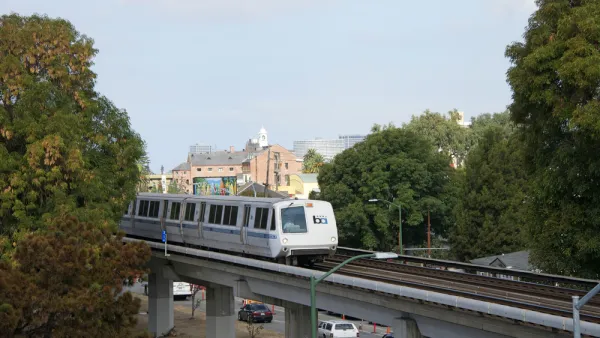
- BART expansion cars: $500 million
- BART to San Jose Phase 2: $375 million
- Caltrain downtown extension: $325 million
- Ferry enhancement program: $300 million
- Bay Area Corridor Express Lanes: $300 million
The expenditure plan [pdf] includes numerous highway projects in addition to the express lanes, such as interchange upgrades, highway widenings, and other highway improvements.
Caltrain sales tax bill signed
A second bill to authorize a Bay Area, multi-county vote was also signed by Gov. Jerry Brown on Oct. 10.
SB 797 by state Sen. Jerry Hill (D-San Mateo) authorizes the Peninsula Corridor Joint Powers Board, which runs Caltrain, to place a one-eighth-cent sales tax on the ballot in San Francisco, San Mateo and Santa Clara counties." [Planetizen, June 26]. Like all other transportation sales tax measures in California, it must pass with a two-thirds supermajority.
The measure is "expected to generate $100 million a year solely for Caltrain and remedy ongoing woes over uneven funding by the three counties," reports The (San Mateo) Daily Journal.
In addition to having to deal with the possible presence of RM 3 on the same ballot, a third transportation funding measure, a much larger sales tax (half-cent), could be placed on San Mateo County ballots next year by the San Mateo County Transit District (SamTrans) due to the signing of AB 1613 by Assemblyman Kevin Mullin (D-South San Francisco). The measure would fund local transportation projects, including Caltrain.
FULL STORY: Bridge toll boost seen as salve for Bay Area transportation woes

Three Transportation Ballot Measures Could Be Headed to Bay Area Voters Next Year
The California Legislature approved bills to allow voters to decide on hiking sales taxes and tolls for regional transportation. Gov. Jerry Brown already signed a bill to allow San Mateo County voters to hike sales taxes for transportation.

Ballot Measure to Hike Bay Area Bridge Tolls Headed for June Ballot
A modest toll increase, $3 over six years, took a major step forward with the approval of a key Bay Area Toll Authority committee. With the exception of the Bay Bridge, the round-trip toll on each of the region's seven state-owned bridges is $5.
Caltrain Electrification Broke Ground on Friday
Gov. Jerry Brown, Peninsula congresswomen, including House Minority Leader Nancy Pelosi, and state legislative leaders gathered in Millbrae with shovels-in hands to mark the beginning of a four-year construction project to electrify Caltrain.

National Parks Layoffs Will Cause Communities to Lose Billions
Thousands of essential park workers were laid off this week, just before the busy spring break season.

Retro-silient?: America’s First “Eco-burb,” The Woodlands Turns 50
A master-planned community north of Houston offers lessons on green infrastructure and resilient design, but falls short of its founder’s lofty affordability and walkability goals.

Delivering for America Plan Will Downgrade Mail Service in at Least 49.5 Percent of Zip Codes
Republican and Democrat lawmakers criticize the plan for its disproportionate negative impact on rural communities.

Test News Post 1
This is a summary

Test News Headline 46
Test for the image on the front page.

Balancing Bombs and Butterflies: How the National Guard Protects a Rare Species
The National Guard at Fort Indiantown Gap uses GIS technology and land management strategies to balance military training with conservation efforts, ensuring the survival of the rare eastern regal fritillary butterfly.
Urban Design for Planners 1: Software Tools
This six-course series explores essential urban design concepts using open source software and equips planners with the tools they need to participate fully in the urban design process.
Planning for Universal Design
Learn the tools for implementing Universal Design in planning regulations.
EMC Planning Group, Inc.
Planetizen
Planetizen
Mpact (formerly Rail~Volution)
Great Falls Development Authority, Inc.
HUDs Office of Policy Development and Research
NYU Wagner Graduate School of Public Service