


Disease mapping made a significant leap forward in the 19th century, and data scientists and geographic information scientists are still contributing to the public health field.
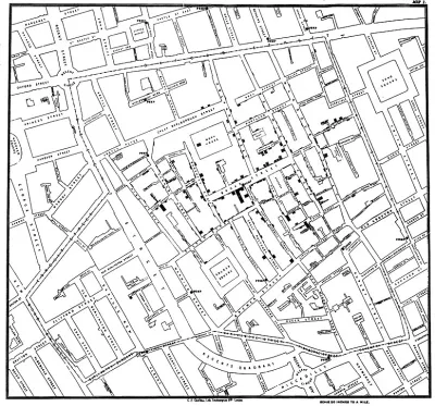
A post on the Sidewalk Labs blog explains an 1854 disease map that "changed the way cities studied public health."
"While many other innovations help keep city residents safe—sewers, fire safety, and vaccines all have more immediately observable effects—the disease map stands out for its ability to change the way we think about population health," according to the post.
Earlier attempts at mapping disease outbreaks failed due to bad assumptions and faulty science, but in 1854 John Snow mapped a London cholera outbreak and totally changed the public health profession's approach to epidemiology—and contributed to a new era of urban growth and industry. (It's no surprise, then, that Snow is often credited as the "father of epidemiology".)
Sidewalk Labs shares Snow's cholera map as the latest installment in the "15 Innovations That Shaped the City" series. According to the post, practices related to data collection and mapping continue to improve, and urban populations can expect even more improvements in public health.
FULL STORY: Disease Mapping: New Technology Meets an Ancient Discipline


Herd Immunity Finds Receptive Audience in White House and Florida
A trio of epidemiologists from Stanford, Harvard, and the University of Oxford have joined the president's new coronavirus medical advisor, Scott Atlas, in promoting an alternative approach to dealing with coronavirus infections.

London Low-Emissions Zone Prompts Shift to Active Modes
More children are using active transportation modes to get to school in the wake of a policy that charges drivers to enter a low-emissions zone in central London.

Do You Know Your COVID-19 Colors?
Harvard University's Global Health Insititute and Edmond J. Safra Center for Ethics have launched a new online tool for planners, policy makers, and the public to determine the severity of the coronavirus outbreak in one's county and state.

National Parks Layoffs Will Cause Communities to Lose Billions
Thousands of essential park workers were laid off this week, just before the busy spring break season.

Retro-silient?: America’s First “Eco-burb,” The Woodlands Turns 50
A master-planned community north of Houston offers lessons on green infrastructure and resilient design, but falls short of its founder’s lofty affordability and walkability goals.

Delivering for America Plan Will Downgrade Mail Service in at Least 49.5 Percent of Zip Codes
Republican and Democrat lawmakers criticize the plan for its disproportionate negative impact on rural communities.

Test News Post 1
This is a summary

Test News Headline 46
Test for the image on the front page.

Balancing Bombs and Butterflies: How the National Guard Protects a Rare Species
The National Guard at Fort Indiantown Gap uses GIS technology and land management strategies to balance military training with conservation efforts, ensuring the survival of the rare eastern regal fritillary butterfly.
Urban Design for Planners 1: Software Tools
This six-course series explores essential urban design concepts using open source software and equips planners with the tools they need to participate fully in the urban design process.
Planning for Universal Design
Learn the tools for implementing Universal Design in planning regulations.
EMC Planning Group, Inc.
Planetizen
Planetizen
Mpact (formerly Rail~Volution)
Great Falls Development Authority, Inc.
HUDs Office of Policy Development and Research
NYU Wagner Graduate School of Public Service