


Satellite images make some of the best maps.
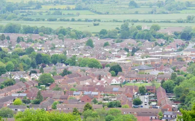
A post on the website of the Local Authority of Building Control (LABC) in the United Kingdom has produced a new map that uses high definition satellite images to plot the different kinds of land development in the United Kingdom.
The maps were created with Corine (coordination of information on the environment) Land Cover data from 2012 which includes 44 different types of land classification including:
- ‘continuous urban fabric’: used to describe the most built up urban areas
- ‘industrial and commercial units’
- ‘green urban’: golf courses, football pitches, parks etc
- ‘farmland’: pasture, arable land, vineyards, orchards
- ‘natural’: moors, forests, lakes
According to the article, the "continuous urban fabric" designation, which applies to areas where 80-100% of the land surface is built on, only accounts for o.1 percent of the land in the United Kingdom. "Another category called 'discontinuous urban fabric', places where between 50% and 80% of the land surface is built on accounts for a mere 5.6%."
Hat tip to H. Pike Oliver for sharing the link to the LABC's post.
FULL STORY: UK land use laid bare by satellite images

Commentary: Why We Need a Federal Definition of ‘Rural’
A patchwork of definitions of rural versus urban areas has real consequences for communities seeking federal funding.

How the Built Environment Affects Your Mood
Humans have survived for millennia by staying together, not apart.

Opinion: Ohio Needs Public Transit
A new Intel facility is set to bring thousands of workers to rural Ohio. Will the state embrace mass transit or give in to auto-centric sprawl?

Analysis: Cybertruck Fatality Rate Far Exceeds That of Ford Pinto
The Tesla Cybertruck was recalled seven times last year.

National Parks Layoffs Will Cause Communities to Lose Billions
Thousands of essential park workers were laid off this week, just before the busy spring break season.

Retro-silient?: America’s First “Eco-burb,” The Woodlands Turns 50
A master-planned community north of Houston offers lessons on green infrastructure and resilient design, but falls short of its founder’s lofty affordability and walkability goals.

Test News Post 1
This is a summary

Analysis: Cybertruck Fatality Rate Far Exceeds That of Ford Pinto
The Tesla Cybertruck was recalled seven times last year.

Test News Headline 46
Test for the image on the front page.
Urban Design for Planners 1: Software Tools
This six-course series explores essential urban design concepts using open source software and equips planners with the tools they need to participate fully in the urban design process.
Planning for Universal Design
Learn the tools for implementing Universal Design in planning regulations.
EMC Planning Group, Inc.
Planetizen
Planetizen
Mpact (formerly Rail~Volution)
Great Falls Development Authority, Inc.
HUDs Office of Policy Development and Research
NYU Wagner Graduate School of Public Service