


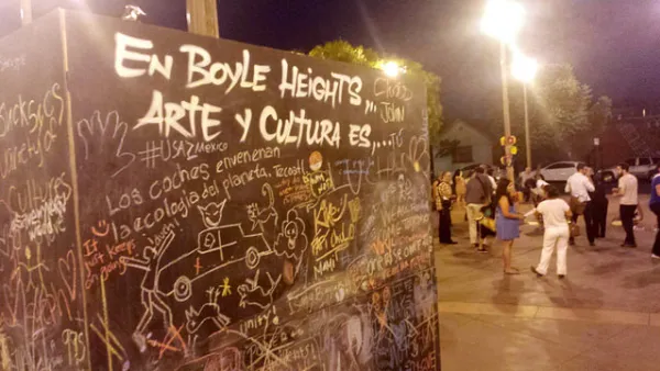
The historically Latino working class neighborhood is a frequent touchstone in debates over gentrification in Los Angeles. That history goes back decades and colors residents' perceptions.

Alfredo Huante unpacks Boyle Heights' long and fraught relationship with L.A. city planning, a story that goes back to the 1960s. The memory of invasive urban renewal, he writes, lingers on despite the fact that Boyle Heights escaped the fate of neighboring "blighted" areas with largely Latino populations.
Huante discusses the rise of community planning in L.A. following the Watts Riots, an early effort to address racial disparities in land use decision making. "Although citizen participation in neighborhood planning was readily encouraged in predominantly white, non-blighted neighborhoods, community plans functioned as the first efforts to solicit and collect barrio residents' input in city planning processes."
Despite those moves, a shift of focus to downtown development under Mayor Tom Bradley again sidelined community planning in Boyle Heights, setting the stage for today's acrimonious debates over development and neighborhood heritage.
Through the late 20th century and into the 21st, Haunte writes, "overarching policies of exclusionary land uses prevailed even if political inclusion improved. With downtown redevelopment jumping the L.A. River into Boyle Heights, ongoing discussions and framing over anti-displacement movements are better understood within this history of dispossession."
FULL STORY: Is Boyle Heights “Worth Saving”?

East Los Angeles Community Groups Prove that Community Planning Matters
The landscape of community development in Los Angeles today differs vastly from even a few years ago. Two groups in East L.A. are developing solutions to accelerating gentrification and displacement and a compounding affordable housing crisis.

Lessons for YIMBYs From Boyle Heights
In the wake of a very pro-development March election, Los Angeles seems ready to embrace change. But not everywhere. In low-income Boyle Heights, residents have been more militant than most against encroaching gentrification.
Clash Over Garden City Apartments in Los Angeles
The Wyvernwood Garden Apartments, a large-scale low-rise development opened in 1939, are at the center of a preservation debate. Lauren Walser gives us the case for keeping them.

National Parks Layoffs Will Cause Communities to Lose Billions
Thousands of essential park workers were laid off this week, just before the busy spring break season.

Retro-silient?: America’s First “Eco-burb,” The Woodlands Turns 50
A master-planned community north of Houston offers lessons on green infrastructure and resilient design, but falls short of its founder’s lofty affordability and walkability goals.

Delivering for America Plan Will Downgrade Mail Service in at Least 49.5 Percent of Zip Codes
Republican and Democrat lawmakers criticize the plan for its disproportionate negative impact on rural communities.

Test News Post 1
This is a summary

Test News Headline 46
Test for the image on the front page.

Balancing Bombs and Butterflies: How the National Guard Protects a Rare Species
The National Guard at Fort Indiantown Gap uses GIS technology and land management strategies to balance military training with conservation efforts, ensuring the survival of the rare eastern regal fritillary butterfly.
Urban Design for Planners 1: Software Tools
This six-course series explores essential urban design concepts using open source software and equips planners with the tools they need to participate fully in the urban design process.
Planning for Universal Design
Learn the tools for implementing Universal Design in planning regulations.
EMC Planning Group, Inc.
Planetizen
Planetizen
Mpact (formerly Rail~Volution)
Great Falls Development Authority, Inc.
HUDs Office of Policy Development and Research
NYU Wagner Graduate School of Public Service