


With limited action at the state level, communities in vulnerable areas have launched their own local preparedness programs and plans.
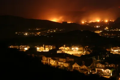
Doug Smith and Ben Welsh report on a Los Angeles Times analysis of buildings located in hazardous wildfire areas in California. "More than 1.1 million structures, or roughly 1 in 10 buildings in California, lie within the highest-risk fire zones in maps drawn by the Department of Forestry and Fire Protection, the analysis showed."
The highest concentration of these structures is in Los Angeles, where 114,000 homes, industrial buildings, and other buildings are located in high-risk areas. San Diego follows with 88,000 buildings. Areas where cities butt up against rocky terrain are the most vulnerable, note Smith and Welsh.
"Although they identify areas where stricter building standards and brush clearance are required, the maps do not directly trigger land-use restrictions or funds to make communities less vulnerable," say Smith and Welsh. The state mandates building codes, but retrofitting existing buildings and disaster preparedness remain largely the responsibility of local jurisdictions and fire departments.
Some communities in Southern California have taken the initiative to prepare for wildfires, where residents and local governments have organized volunteer arson watch and emergency response teams, conducted fire risk assessments, and held public meetings about safety and evacuation plans. However, many of these efforts still remain largely untested, since these are areas that were minimally affected by recent wildfires.
FULL STORY: A million California buildings face wildfire risk. ‘Extraordinary steps’ are needed to protect them

Resilient Communities, Healthy Ecosystems: A Balanced Approach to Wildfires
Effective wildfire mitigation in California requires a holistic approach that goes beyond large-scale vegetation removal, emphasizing home hardening, defensible space, strategic planning, and reducing human-caused ignitions.
California Faces Costly Measures in Preparing for Future Wildfires
In California, recovery after wildfires means many upfront investments by communities and the state.
Wildfire Risks Make Southern California Development a Gamble
The Tejon Ranch development would bring thousands of homes to a highly fire-prone area in L.A. County.

National Parks Layoffs Will Cause Communities to Lose Billions
Thousands of essential park workers were laid off this week, just before the busy spring break season.

Retro-silient?: America’s First “Eco-burb,” The Woodlands Turns 50
A master-planned community north of Houston offers lessons on green infrastructure and resilient design, but falls short of its founder’s lofty affordability and walkability goals.

Delivering for America Plan Will Downgrade Mail Service in at Least 49.5 Percent of Zip Codes
Republican and Democrat lawmakers criticize the plan for its disproportionate negative impact on rural communities.

Test News Post 1
This is a summary

Test News Headline 46
Test for the image on the front page.

Balancing Bombs and Butterflies: How the National Guard Protects a Rare Species
The National Guard at Fort Indiantown Gap uses GIS technology and land management strategies to balance military training with conservation efforts, ensuring the survival of the rare eastern regal fritillary butterfly.
Urban Design for Planners 1: Software Tools
This six-course series explores essential urban design concepts using open source software and equips planners with the tools they need to participate fully in the urban design process.
Planning for Universal Design
Learn the tools for implementing Universal Design in planning regulations.
EMC Planning Group, Inc.
Planetizen
Planetizen
Mpact (formerly Rail~Volution)
Great Falls Development Authority, Inc.
HUDs Office of Policy Development and Research
NYU Wagner Graduate School of Public Service