


A Reddit user created a transit map of the San Francisco Bay Area that connects Taco Bell locations, which, unlike rail public transit, have reached every corner of the region.
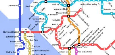
Reddit user u/Epicapabilities, actually 16-year-old Jeff McGough, a high school student from Minnesota, created a Taco Bell-connected fantasy map of rail transit in the San Francisco Bay Area and environs that won attention recently. The map spreads from Dixon to Rio Vista to Cloverdale to Manteca to Monterey, with all the Tracys, Gilroys, Redwood Citys, Santa Rosas, and Cordelias between included.
I grew up near the Clayton Rd station imagined on the map and frequented the Taco Bell in question before I knew any better, but I don't see an advertisement for bad fast food in this map. I see the fantasy transit map of the region I grew up in if cars had somehow skipped the 20th century. Sure, there are too many transfers on this map. I'm sure people in Vallejo and Benicia would love a one-seat ride into The City.
Still. Imagine such a world. Then again, it's hard to imagine Taco Bell being so ubiquitous in a world without cars. Is that a win-win?
McGough also created a similar map for Whataburger locations in Austin, Target in the Twin Cities, and Taco Bells in cities all over the country. Taco Bell picked up McGough's work for its blog.
FULL STORY: If Taco Bell connected their locations with a rail system


Friday Eye Candy: Mapping the Nation's Internet Trolls
Finally, we know where Internet trolls come from—no, not the basements of parents' houses.
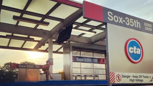
$2 Billion Federal Grant for Red Line Extension Project to Chicago’s South Side
A plan to extend the Chicago Transit Authority (CTA) Red Line 5.6 miles to the south won a $2 billion grant from the federal government.
Virginia Passenger Rail Sets Ridership Records, Seeks More Wins
Virginia’s commitment to intercity rail is paying off in record ridership numbers, but more work will be necessary to achieve the state’s ambitions for passenger rail.

Analysis: Cybertruck Fatality Rate Far Exceeds That of Ford Pinto
The Tesla Cybertruck was recalled seven times last year.

National Parks Layoffs Will Cause Communities to Lose Billions
Thousands of essential park workers were laid off this week, just before the busy spring break season.

Retro-silient?: America’s First “Eco-burb,” The Woodlands Turns 50
A master-planned community north of Houston offers lessons on green infrastructure and resilient design, but falls short of its founder’s lofty affordability and walkability goals.

Test News Post 1
This is a summary

Analysis: Cybertruck Fatality Rate Far Exceeds That of Ford Pinto
The Tesla Cybertruck was recalled seven times last year.

Test News Headline 46
Test for the image on the front page.
Urban Design for Planners 1: Software Tools
This six-course series explores essential urban design concepts using open source software and equips planners with the tools they need to participate fully in the urban design process.
Planning for Universal Design
Learn the tools for implementing Universal Design in planning regulations.
EMC Planning Group, Inc.
Planetizen
Planetizen
Mpact (formerly Rail~Volution)
Great Falls Development Authority, Inc.
HUDs Office of Policy Development and Research
NYU Wagner Graduate School of Public Service