


How people get to work, and the geographic distinctions between trends in those choices, reveals some of the country's more ominous traits, including the trend Richard Florida calls "the new urban crisis."
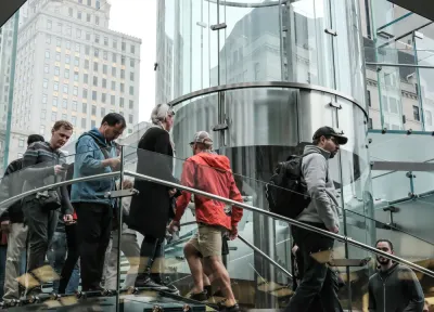
Richard Florida digs deeper into data recently released by the American Community Survey to make the case that how people move around cities is a key feature of the country's "deepening economic and political fissures."
The post includes maps that reveal where Americans get to work by car, public transit, biking, walking, and carpooling. Florida also digs into factors of mode choice like size and density of location, educational attainment, economic class, weather, and more.
As for what it all means, Florida says the country's political cleavages follow the same lines as the mode choices commuter make around the country. And then theirs is the deepening economic and social inequality Florida has dubbed the "new urban crisis":
Our commuting patterns are associated with key dimensions of what I dub the new urban crisis. Housing is less affordable, inequality greater, and economic segregation higher in places where commuters are less dependent on the car. Median housing costs are positively and significantly associated with transit (0.59), biking (0.48), carpooling (0.49), and walking (0.38) to work, and so are income inequality and economic segregation. These associations again reflect the fact that denser, more affluent, educated metros are more expensive, more unequal, and more segregated.
FULL STORY: The Great Divide in How Americans Commute to Work

New Commute Data: Telecommuting on the Rise
The news from the most recent American Community Survey data isn't entirely bad for advocates hoping that Americans will switch to more efficient, less impactful forms of commuting.
Travel Trends: Are They Changing?
Recently released travel data show Americans returning to their cars as the economic recovery deepens. Alternative forms of transportation are not attracting new users.

Slowly But Surely, Commutes Are Changing
Finding the answers to the questions posed by the latest transportation data from the American Community Survey will determine the best use of limited resources for infrastructure investment and planning.

National Parks Layoffs Will Cause Communities to Lose Billions
Thousands of essential park workers were laid off this week, just before the busy spring break season.

Retro-silient?: America’s First “Eco-burb,” The Woodlands Turns 50
A master-planned community north of Houston offers lessons on green infrastructure and resilient design, but falls short of its founder’s lofty affordability and walkability goals.

Delivering for America Plan Will Downgrade Mail Service in at Least 49.5 Percent of Zip Codes
Republican and Democrat lawmakers criticize the plan for its disproportionate negative impact on rural communities.

Test News Post 1
This is a summary

Test News Headline 46
Test for the image on the front page.

Balancing Bombs and Butterflies: How the National Guard Protects a Rare Species
The National Guard at Fort Indiantown Gap uses GIS technology and land management strategies to balance military training with conservation efforts, ensuring the survival of the rare eastern regal fritillary butterfly.
Urban Design for Planners 1: Software Tools
This six-course series explores essential urban design concepts using open source software and equips planners with the tools they need to participate fully in the urban design process.
Planning for Universal Design
Learn the tools for implementing Universal Design in planning regulations.
EMC Planning Group, Inc.
Planetizen
Planetizen
Mpact (formerly Rail~Volution)
Great Falls Development Authority, Inc.
HUDs Office of Policy Development and Research
NYU Wagner Graduate School of Public Service