


An interactive map shows the surprising density of the Garden State.
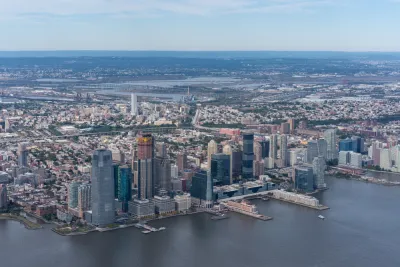
"The Garden State is home to the top four most densely populated municipalities in the United States, and seven of the top 10," according to this article by Stephen Stirling.
In fact, every good New Jersey resident is taught that the state is the densest state of all 50 United States, according to Stirling. "But some of the minutiae that make up that statewide statistic is staggering."
That's where an interactive map produced by NJ Advance Media for NJ.com comes in handy for illustrating the point. The visualization renders clearly the big four of density in the state—Guttenberg, Union City, West New York, and Hoboken—and the population groupings along the shore.
For the less populated corner of the state, look to the southwest, where Salem and Cumberland counties remain largely farmland. "But though the area remains largely farmland, communities have clustered around small, more tightly-packed community centers. Viewed in 3D, small but dense towns like Elmer, Bridgeton and Salem City stick out like sore thumbs," writes Stirling.
FULL STORY: 3D maps show parts of NJ are the most densely populated on the planet


Measuring Job Densification Trends in U.S. Metropolitan Areas
A new report details the trend of jobs densification in U.S. metropolitan areas between 2004 and 2015, finding a few large metropolitan areas leading an overall increase in jobs density. Still, many areas are seeing jobs disperse around the region.
Compare Transit Ridership in U.S. Cities
A new interactive tool called Transit Insights offers access to the local trends of transit ridership.
Pop Quiz: Can You Identify Cities By Density Alone?
A Planetizen editor failed this quiz.

National Parks Layoffs Will Cause Communities to Lose Billions
Thousands of essential park workers were laid off this week, just before the busy spring break season.

Retro-silient?: America’s First “Eco-burb,” The Woodlands Turns 50
A master-planned community north of Houston offers lessons on green infrastructure and resilient design, but falls short of its founder’s lofty affordability and walkability goals.

Delivering for America Plan Will Downgrade Mail Service in at Least 49.5 Percent of Zip Codes
Republican and Democrat lawmakers criticize the plan for its disproportionate negative impact on rural communities.

Test News Post 1
This is a summary

Test News Headline 46
Test for the image on the front page.

Balancing Bombs and Butterflies: How the National Guard Protects a Rare Species
The National Guard at Fort Indiantown Gap uses GIS technology and land management strategies to balance military training with conservation efforts, ensuring the survival of the rare eastern regal fritillary butterfly.
Urban Design for Planners 1: Software Tools
This six-course series explores essential urban design concepts using open source software and equips planners with the tools they need to participate fully in the urban design process.
Planning for Universal Design
Learn the tools for implementing Universal Design in planning regulations.
EMC Planning Group, Inc.
Planetizen
Planetizen
Mpact (formerly Rail~Volution)
Great Falls Development Authority, Inc.
HUDs Office of Policy Development and Research
NYU Wagner Graduate School of Public Service