


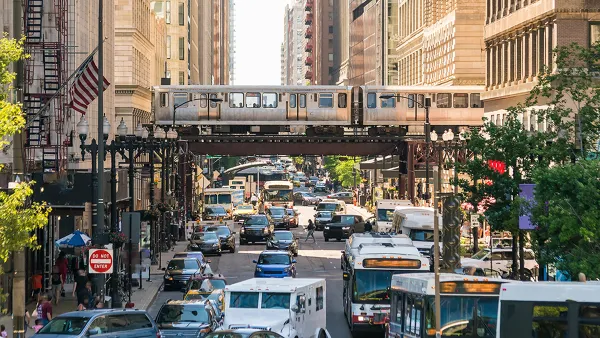
Liberty Street was once a narrow, urban street. Now it's seven lanes of unsafe speeds and pedestrian risks. The city has a plan to greatly reduce the number of traffic lanes on the street, or another plan that won't.

"A years-in-the-making redesign of Liberty Street -- one of Cincinnati's most vital and heavily-traveled roads -- might have taken one step closer to reality this week," reports Pat LaFleur.
Or not. There is plenty of reason to be skeptical about the likelihood of the project ever reaching completion, according to LaFleur. Local residents have been calling for the road diet to reduce speeds and increase safety for all users for years. According to data from the Cincinnati Police Department, Liberty Street has seen 1,700 traffic collisions since 2013, 30 involving pedestrians.
The city is currently considering two plans for the seven-lane street. One is the "road diet" configuration, which would shrink the road to five vehicle travel lanes. That alternative has support from a supermajority of Cincinnati councilmembers. The other planwould preserve all seven vehicle travel lanes, but add bump-outs at six intersections along the street. That plan has the support of Mayor John Cranley.
"The biggest conflict still stirring among lawmakers centers around what is a perpetual challenge for Over-the-Rhine: on-street parking," according to LaFleur. "Cranley's argument -- as well as several speakers at Monday's hearing -- is that the neighborhood cannot afford to lose all-day on-street parking."
FULL STORY: Will Liberty Street ever get its 'road diet'?

Planning for Congestion Relief
The third and final installment of Planetizen's examination of the role of the planning profession in both perpetuating and solving traffic congestion.

How Planning Fails to Solve Congestion
Solutions for congestion are never as simple and easy as armchair planners and engineers would like you to believe—especially those who suggest that congestion can be solved by forever building more roadway capacity.
Planning and the Complicated Causes and Effects of Congestion
What do planners know about congestion, and what can they do about it? Explanations and solutions are less obvious than they seem (part one of a three-part series).

National Parks Layoffs Will Cause Communities to Lose Billions
Thousands of essential park workers were laid off this week, just before the busy spring break season.

Retro-silient?: America’s First “Eco-burb,” The Woodlands Turns 50
A master-planned community north of Houston offers lessons on green infrastructure and resilient design, but falls short of its founder’s lofty affordability and walkability goals.

Delivering for America Plan Will Downgrade Mail Service in at Least 49.5 Percent of Zip Codes
Republican and Democrat lawmakers criticize the plan for its disproportionate negative impact on rural communities.

Test News Post 1
This is a summary

Test News Headline 46
Test for the image on the front page.

Balancing Bombs and Butterflies: How the National Guard Protects a Rare Species
The National Guard at Fort Indiantown Gap uses GIS technology and land management strategies to balance military training with conservation efforts, ensuring the survival of the rare eastern regal fritillary butterfly.
Urban Design for Planners 1: Software Tools
This six-course series explores essential urban design concepts using open source software and equips planners with the tools they need to participate fully in the urban design process.
Planning for Universal Design
Learn the tools for implementing Universal Design in planning regulations.
EMC Planning Group, Inc.
Planetizen
Planetizen
Mpact (formerly Rail~Volution)
Great Falls Development Authority, Inc.
HUDs Office of Policy Development and Research
NYU Wagner Graduate School of Public Service