


In the face of displacement and gentrification, residents of the Fruit Belt neighborhood of Buffalo, NY point to tech-giant Google's map service as one among many possible causes.
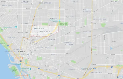
In the late 2000s, public outcry over the development of the Buffalo Niagara Medical Campus in the Fruit Belt neighborhood of Buffalo, NY brought shed light on a complex community identity conflict. Residents saw their drastically changing neighborhood undergo rapid transformation and gentrification. In addition to this displacement, they observed that the name of their neighborhood, the "Fruit Belt," was erased from Google Maps and replaced with the name "Medical Park."
In the historically Black and German immigrant neighborhood, "community members argued the designation was a calculated tweak in favor of gentrification, a digital rechristening," writes Caitlin Dewey. "The misnomer also revealed a great deal about the invisible process major tech firms use to put neighborhoods on their maps—and how decisions based off arcane data sets can affect communities thousands of miles away."
Digital erasure is not the only way the ownership of the Fruit Belt was forcibly removed from long-time residents, notes Dewey:
[D]evelopers tore down low-income townhouses and bought out a nearby African-American cultural center to make way for new apartments and medical offices. Worse, some residents reported rent hikes of as much as 50 percent, and one in three homes sat vacant and unused — a common sign that owners planned to resell them at a higher price.
As a result of Dewey's journalistic research, Good Maps corrected the name of the Fruit Belt. This acknowledgement of collective community autonomy is only a small step in the right direction.
FULL STORY: How Google's Bad Data Wiped a Neighborhood off the Map


10 U.S. Cities Launch Anti-Displacement Network
More than half of American tenants are rent-burdened, putting them at risk of displacement. A national collaboration with PolicyLink hopes to help.

Commentary: A New ‘Grand Bargain’ for American Housing
For decades, many U,S, neighborhoods successfully resisted change at the expense of a few neighborhoods sacrificed to mass development. Is there a better way?
Can We Resist Displacement From Transit-Oriented Development?
Transit stations increase nearby jobs and populations, but they could also contribute to displacement. What can we do differently?

National Parks Layoffs Will Cause Communities to Lose Billions
Thousands of essential park workers were laid off this week, just before the busy spring break season.

Retro-silient?: America’s First “Eco-burb,” The Woodlands Turns 50
A master-planned community north of Houston offers lessons on green infrastructure and resilient design, but falls short of its founder’s lofty affordability and walkability goals.

Delivering for America Plan Will Downgrade Mail Service in at Least 49.5 Percent of Zip Codes
Republican and Democrat lawmakers criticize the plan for its disproportionate negative impact on rural communities.

Test News Post 1
This is a summary

Test News Headline 46
Test for the image on the front page.

Balancing Bombs and Butterflies: How the National Guard Protects a Rare Species
The National Guard at Fort Indiantown Gap uses GIS technology and land management strategies to balance military training with conservation efforts, ensuring the survival of the rare eastern regal fritillary butterfly.
Urban Design for Planners 1: Software Tools
This six-course series explores essential urban design concepts using open source software and equips planners with the tools they need to participate fully in the urban design process.
Planning for Universal Design
Learn the tools for implementing Universal Design in planning regulations.
EMC Planning Group, Inc.
Planetizen
Planetizen
Mpact (formerly Rail~Volution)
Great Falls Development Authority, Inc.
HUDs Office of Policy Development and Research
NYU Wagner Graduate School of Public Service