


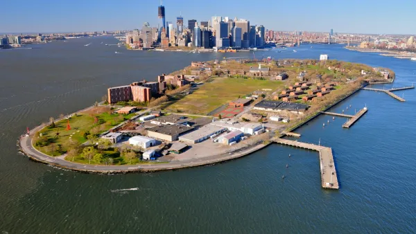
The island's 40-acre park is a recreational destination, but waterfront advocates would like to see more use of Governor Island's shoreline and maritime infrastructure.

The Waterfront Alliance has released a new plan for Governors Island in New York, with a focus on the island’s 2.2 miles of coastline, reports Daniel Geiger:
Among the alliance's ideas are to create more places for visitors to explore the water, including by allowing access to a natural sand beach along Buttermilk Channel, which flows between the island and Brooklyn. A marina could be built to encourage recreational boaters to visit. Reorganizing the island's six working piers and boat landings could create more space for bigger vessels with scientific or historic value to dock.
Additional recommendations include increased ferry service between the island and various boroughs and separation of freight and garbage transport from ferry service. "The alliance wasn’t able to immediately say what its recommendations could cost to implement. Redeveloping piers to accommodate garbage and freight transfers and large visiting ships can run into the many millions of dollars," writes Geiger.
FULL STORY: Waterfront advocates set sights on Governors Island


Rezoning for Governors Island Approved
A mix of new development focused on future needs and new tools for preservation are included in the rezoning package for the south end of Governors Island approved by the New York City Council in May.
Massive Climate Research Center Planned for Governors Island, Rezoning Now Included
A speculative but exceedingly ambitious plan is pressing for air time in New York City.

Aging New York City Parks in Desperate Need of Repairs
The city’s parks are facing a crisis on the horizon resulting from a lack of maintenance and growing capital improvement needs.

National Parks Layoffs Will Cause Communities to Lose Billions
Thousands of essential park workers were laid off this week, just before the busy spring break season.

Retro-silient?: America’s First “Eco-burb,” The Woodlands Turns 50
A master-planned community north of Houston offers lessons on green infrastructure and resilient design, but falls short of its founder’s lofty affordability and walkability goals.

Delivering for America Plan Will Downgrade Mail Service in at Least 49.5 Percent of Zip Codes
Republican and Democrat lawmakers criticize the plan for its disproportionate negative impact on rural communities.

Test News Post 1
This is a summary

Test News Headline 46
Test for the image on the front page.

Balancing Bombs and Butterflies: How the National Guard Protects a Rare Species
The National Guard at Fort Indiantown Gap uses GIS technology and land management strategies to balance military training with conservation efforts, ensuring the survival of the rare eastern regal fritillary butterfly.
Urban Design for Planners 1: Software Tools
This six-course series explores essential urban design concepts using open source software and equips planners with the tools they need to participate fully in the urban design process.
Planning for Universal Design
Learn the tools for implementing Universal Design in planning regulations.
EMC Planning Group, Inc.
Planetizen
Planetizen
Mpact (formerly Rail~Volution)
Great Falls Development Authority, Inc.
HUDs Office of Policy Development and Research
NYU Wagner Graduate School of Public Service