


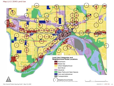
The St. Paul 2040 Comprehensive Plan aims for missing middle density at 56 "Neighborhood Nodes" around the city.
Frederick Melo reports on the details of the new 20-year comprehensive plan for St. Paul, under consideration at a series of public meetings this month and expected for a City Council by January.
According to Melo, the "St. Paul for All 2040 Comprehensive Plan" focuses growth around "Neighborhood Nodes":
St. Paul wants and needs to grow, and to do that, city planners have pinpointed 56 intersections where denser new housing, retail, transit stops and other important services could happily co-exist. That may mean lifting zoning and density restrictions, or taking advantage of zoning that already exists, to incorporate these future “neighborhood nodes” into local planning.
The entire comprehensive plan is split into six chapters, on land use, transportation, parks and open space, housing, water resources, and historic preservation, according to Melo's explanation. "The chapters touch on six themes — urban design, economic development, resiliency in the face of intense environmental changes, public health, helping residents remain in their neighborhoods as they age, and reducing racial disparities through equitable distribution of city services."
FULL STORY: St. Paul’s 20-year plan calls for more development at 56 neighborhood intersections


Charlotte's New, Controversial Comprehensive Plan to End Single-Family Zoning
A tight vote after months of controversy has produced a major zoning reform effort that differs significantly from recent examples on the West Coast and in Minneapolis.
D.C. Comprehensive Plan Amendments Approved
New amendments to the D.C. Comprehensive Plan set goals for new housing development and fewer cars on the road.
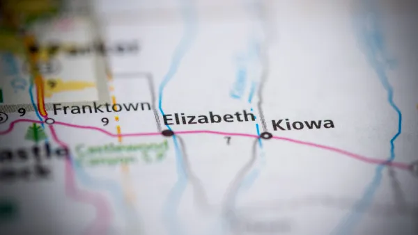
Rapid Growth and a Small Town Recall Effort
A group of organizers in the small town of Elizabeth, Colorado (population 1,700) wants to recall its entire City Council as an act of defiance in the face of rapid change and growth.

National Parks Layoffs Will Cause Communities to Lose Billions
Thousands of essential park workers were laid off this week, just before the busy spring break season.

Retro-silient?: America’s First “Eco-burb,” The Woodlands Turns 50
A master-planned community north of Houston offers lessons on green infrastructure and resilient design, but falls short of its founder’s lofty affordability and walkability goals.

Delivering for America Plan Will Downgrade Mail Service in at Least 49.5 Percent of Zip Codes
Republican and Democrat lawmakers criticize the plan for its disproportionate negative impact on rural communities.

Test News Post 1
This is a summary

Test News Headline 46
Test for the image on the front page.

Balancing Bombs and Butterflies: How the National Guard Protects a Rare Species
The National Guard at Fort Indiantown Gap uses GIS technology and land management strategies to balance military training with conservation efforts, ensuring the survival of the rare eastern regal fritillary butterfly.
Urban Design for Planners 1: Software Tools
This six-course series explores essential urban design concepts using open source software and equips planners with the tools they need to participate fully in the urban design process.
Planning for Universal Design
Learn the tools for implementing Universal Design in planning regulations.
EMC Planning Group, Inc.
Planetizen
Planetizen
Mpact (formerly Rail~Volution)
Great Falls Development Authority, Inc.
HUDs Office of Policy Development and Research
NYU Wagner Graduate School of Public Service