


New data from Fehr & Peers shows services like Uber and Lyft account for a larger share of the total traffic than previously thought, especially in city centers.
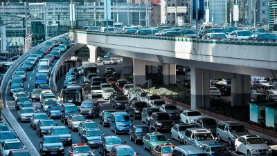
In Boston’s Suffolk County about 1 in every 13 miles driven is driven for Uber or Lyft.
That’s just one of a slew of interesting pieces of information released by Fehr & Peers on how many miles ride-hailing cars travel. Vehicle miles traveled, or VMT, have been climbing in the United States since the economic recession of 2008. Many things have changed since then in the world of transportation, including the arrival and growth of ride-hailing services. This upward trend in miles traveled has meant an upward trend in vehicle emissions, including those that contribute to climate change. Initially there was some hope that ride hailing might actually curb VMT (a hope ride sharing companies were eager to promote), but this study (among others) shows that that has not happened.
The study shows the percent of VMT from ride-hailing companies for cities like Boston (8.5%), San Francisco (13.4%), and Washington D.C. (7.2%). "These numbers suggest that ride-hailing is hitting traffic harder in many cities than previously understood," Laura Bliss writes for CityLab.
Data also shows that the traffic is most concentrated in regions that are well served by public transit. In some cases, a Lyft or Uber ride may entail more VMT than would a private vehicle—as much of the distance these vehicles travel is without a passenger. "On average, between the six cities, just 54 to 62 percent of the vehicle miles traveled by Lyfts and Ubers were with a rider in tow," Bliss reports.
FULL STORY: How Much Traffic Do Uber and Lyft Cause?

Report: Ride-Hailing Drastically Increases Vehicle Miles Traveled
New research published in Transport Policy finds that ride-hailing companies increase vehicle miles traveled of users by 97 percent in Chicago, 114 percent in New York City, and 118 percent in San Francisco.

Uber and Lyft Reveal Seattle-Area Trip Data
After a court battle, the two big transportation network companies finally released trip data, revealing rapid growth and a concentration of rides in the city's most congested areas.

Chicago Could Be Next to Cap Number of Ride-Hailing Vehicles
After New York City approved a similar law earlier in Agust, two Chicago alderman have proposed a law that would limit the number of vehicles operating for transportation network companies like Uber and Lyft.

National Parks Layoffs Will Cause Communities to Lose Billions
Thousands of essential park workers were laid off this week, just before the busy spring break season.

Retro-silient?: America’s First “Eco-burb,” The Woodlands Turns 50
A master-planned community north of Houston offers lessons on green infrastructure and resilient design, but falls short of its founder’s lofty affordability and walkability goals.

Delivering for America Plan Will Downgrade Mail Service in at Least 49.5 Percent of Zip Codes
Republican and Democrat lawmakers criticize the plan for its disproportionate negative impact on rural communities.

Test News Post 1
This is a summary

Test News Headline 46
Test for the image on the front page.

Balancing Bombs and Butterflies: How the National Guard Protects a Rare Species
The National Guard at Fort Indiantown Gap uses GIS technology and land management strategies to balance military training with conservation efforts, ensuring the survival of the rare eastern regal fritillary butterfly.
Urban Design for Planners 1: Software Tools
This six-course series explores essential urban design concepts using open source software and equips planners with the tools they need to participate fully in the urban design process.
Planning for Universal Design
Learn the tools for implementing Universal Design in planning regulations.
EMC Planning Group, Inc.
Planetizen
Planetizen
Mpact (formerly Rail~Volution)
Great Falls Development Authority, Inc.
HUDs Office of Policy Development and Research
NYU Wagner Graduate School of Public Service