


A call for cities like New York to accurately map, model, and share information on underground water and utility infrastructure for public benefit.
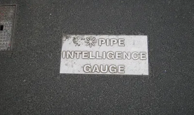
Alan Leidner writes about the need to daylight information about the underground infrastructure that makes New York City work—not the subways, "the tangle of gas, electric, water and steam lines on which the city depends."
Leidner, president of the Geospatial Information Systems and Mapping Organization and former director of Citywide GIS at the New York City Department of Information Technology and Telecommunications, is an expert on the subject.
Unfortunately, there is no combined data set showing location and condition of all utility infrastructure. Lack of awareness drives up the cost of capital infrastructure projects. (In the case of Super Storm Sandy in 2012, for instance, New York City could have reduced its $19 billion repair bill if only it had better data capture, sharing and analysis.) Lack of awareness prolongs emergency recovery. And, in the worst cases, it proves fatal when volatile components trigger catastrophe such as a water main break causing a gas main explosion.
Leidner's argument is that the technology exists to link geographic information system (GIS) data to building information modeling (BIM) to create a sophisticated and powerful map of the city's underground systems. That information can then be used for "risk analysis of storms, floods, earthquakes or other disasters," and to "help detect single points of failure, triggers for cascading events, vulnerabilities and interdependencies."
Leidner points to the city of Auckland, in Australia, as an example of a connected model of underground infrastructure, along with Flanders, London, Helsinki, Zurich, Melbourne, Singapore, and Hong Kong.
Moreover, according to Leidner: "The Open Geospatial Consortium (OGC), the data standards organization of the GIS community, has been working over the past three years to develop a data model that allows information from all utilities to be combined and analyzed."
FULL STORY: City's underground infrastructure needs to be mapped and shared

Using Machine Learning to Optimize Utility Management
Discover how machine learning optimizes city utility management for enhanced efficiency and reduced operational costs.
Building Resiliency in Rural Power Grids
A National Science Foundation study seeks to understand the impact of climate change and extreme weather on rural electrical grids in diverse geographic areas.
Utilities Spending Less on Energy Efficiency Despite Higher Fuel Prices
A survey of major utilities reveals a link between states with strict efficiency standards and incentive programs and efforts to improve efficiency on the part of utilities.

Analysis: Cybertruck Fatality Rate Far Exceeds That of Ford Pinto
The Tesla Cybertruck was recalled seven times last year.

National Parks Layoffs Will Cause Communities to Lose Billions
Thousands of essential park workers were laid off this week, just before the busy spring break season.

Retro-silient?: America’s First “Eco-burb,” The Woodlands Turns 50
A master-planned community north of Houston offers lessons on green infrastructure and resilient design, but falls short of its founder’s lofty affordability and walkability goals.

Test News Post 1
This is a summary

Analysis: Cybertruck Fatality Rate Far Exceeds That of Ford Pinto
The Tesla Cybertruck was recalled seven times last year.

Test News Headline 46
Test for the image on the front page.
Urban Design for Planners 1: Software Tools
This six-course series explores essential urban design concepts using open source software and equips planners with the tools they need to participate fully in the urban design process.
Planning for Universal Design
Learn the tools for implementing Universal Design in planning regulations.
EMC Planning Group, Inc.
Planetizen
Planetizen
Mpact (formerly Rail~Volution)
Great Falls Development Authority, Inc.
HUDs Office of Policy Development and Research
NYU Wagner Graduate School of Public Service