


Though it stops well short of a citywide upzoning, the city of Tacoma has still expanded its planned development envelope by upzoning residential neighborhoods around the city.
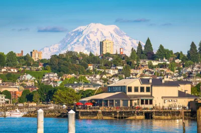
"In late September, the Tacoma City Council approved a large slate of areawide rezones and future land use map designation changes, which primarily affected residential properties," reports Stephen Fesler.
"The rezones and land use designation changes were included as part of the annual Comprehensive Plan update process for minor amendments, which were proposed in order to attain consistency between zoning and land use designations," adds Fesler.
According to Fesler, the changes amount to an upzoning, allowing more development intensity in residential areas in the city. "Where zoning of a site was less intensive or inconsistent with a future land use map (FLUM) designation type, the highest and most consistent implementing zoning type was proposed," according to Fesler. Still, Fesler warns, the effect fo the changes should not be overstated: "The changes adopted by the city council represent a small fraction of single-family areas and an even smaller fraction of the city, but they should help the city expand overall development capacity."
FULL STORY: Tacoma Quietly Rezoned Residential Areas in Latest Comp Plan Update


Minneapolis Draft Comprehensive Plan Would Allow Fourplexes in Single-Family Neighborhoods
If the rezoning of single-family neighborhoods succeeds in Minneapolis as part of its ongoing Comprehensive Plan process, we could be looking at one of the most ambitious pro-development zoning schemes in the country.
A Small Town Makes its First Zoning Update Since 1997
Mixed-use development and a floodplain overlay are the big-ticket items when the small community of Akron Borough in Pennsylvania recently updated its zoning code.

Pittsburgh Moves Ahead With Zoning Changes for University-Adjacent Neighborhood
The implementation of a new master plan for the neighborhood of Oakland, home to the University of Pittsburgh, is moving forward despite controversy and a contentious community engagement process.

National Parks Layoffs Will Cause Communities to Lose Billions
Thousands of essential park workers were laid off this week, just before the busy spring break season.

Retro-silient?: America’s First “Eco-burb,” The Woodlands Turns 50
A master-planned community north of Houston offers lessons on green infrastructure and resilient design, but falls short of its founder’s lofty affordability and walkability goals.

Delivering for America Plan Will Downgrade Mail Service in at Least 49.5 Percent of Zip Codes
Republican and Democrat lawmakers criticize the plan for its disproportionate negative impact on rural communities.

Test News Post 1
This is a summary

Test News Headline 46
Test for the image on the front page.

Balancing Bombs and Butterflies: How the National Guard Protects a Rare Species
The National Guard at Fort Indiantown Gap uses GIS technology and land management strategies to balance military training with conservation efforts, ensuring the survival of the rare eastern regal fritillary butterfly.
Urban Design for Planners 1: Software Tools
This six-course series explores essential urban design concepts using open source software and equips planners with the tools they need to participate fully in the urban design process.
Planning for Universal Design
Learn the tools for implementing Universal Design in planning regulations.
EMC Planning Group, Inc.
Planetizen
Planetizen
Mpact (formerly Rail~Volution)
Great Falls Development Authority, Inc.
HUDs Office of Policy Development and Research
NYU Wagner Graduate School of Public Service