


Trends in land use and development are made obvious with satellite imagery tracking changes during the 2010s.
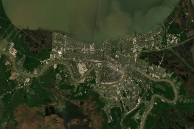
Emily Badger and Quoctrung Bui of The New York Times, worked with Tim Wallace and Krishna Karra from Descartes Labs, a geospatial analytics company to track trends in development over the past decade.
"With [satellite imagery's] growing power and precision, we can see both intimate details — a single home, bulldozed; a tennis court, reinvented — and big patterns that recur across the country," write Badger and Bui.
The trends they spot from above are illustrated in the source article, but they read as follows:
- The Exurbs Boom Again
- The Urban Core, Redeveloped
- Diversity Becomes the Norm
- Big Tech's Imprint
- Big Tech's Big Boxes
- Rust Belt Homes, Demolished
- Transit Transformations
- After Disaster, Renewal
FULL STORY: A Decade of Urban Transformation, Seen From Above


Planning for Proximity, for the Climate’s Sake
A new global platform will help the world identify and encourage opportunities for more proximity in the built environment—development patterns that can help reduce sources of greenhouse gas emissions and other forms of pollution if built well.

Snohomish County, Washington, Sets its Sights on Sprawl
Advocates say it’s unnecessary, but Snohomish County is preparing to expand its urban growth areas to allow for more low density residential development.

Planning for Congestion Relief
The third and final installment of Planetizen's examination of the role of the planning profession in both perpetuating and solving traffic congestion.

National Parks Layoffs Will Cause Communities to Lose Billions
Thousands of essential park workers were laid off this week, just before the busy spring break season.

Retro-silient?: America’s First “Eco-burb,” The Woodlands Turns 50
A master-planned community north of Houston offers lessons on green infrastructure and resilient design, but falls short of its founder’s lofty affordability and walkability goals.

Delivering for America Plan Will Downgrade Mail Service in at Least 49.5 Percent of Zip Codes
Republican and Democrat lawmakers criticize the plan for its disproportionate negative impact on rural communities.

Test News Post 1
This is a summary

Test News Headline 46
Test for the image on the front page.

Balancing Bombs and Butterflies: How the National Guard Protects a Rare Species
The National Guard at Fort Indiantown Gap uses GIS technology and land management strategies to balance military training with conservation efforts, ensuring the survival of the rare eastern regal fritillary butterfly.
Urban Design for Planners 1: Software Tools
This six-course series explores essential urban design concepts using open source software and equips planners with the tools they need to participate fully in the urban design process.
Planning for Universal Design
Learn the tools for implementing Universal Design in planning regulations.
EMC Planning Group, Inc.
Planetizen
Planetizen
Mpact (formerly Rail~Volution)
Great Falls Development Authority, Inc.
HUDs Office of Policy Development and Research
NYU Wagner Graduate School of Public Service