


The planning profession can contribute to the worldwide fight to control the spread of COVID-19. GIS technology, for instance, allows real-time monitoring of the pandemic.

Esri, the California-based geographic information systems (GIS) company, has launched the online "COVID-19 GIS Hub" with a number of useful tools for tracking information about the spread and mitigation of coronavirus disease around the world.
Tools include a deeply informative "Coronavirus COVID-19 Global Cases" dashboard, created by the Center for Systems Science and Engineering at Johns Hopkins University, and a COVID-19 Surveillance Dashboard, created by the Biocomplexity Institute at the University of Virginia. The Esri hub also offers GIS apps that illustrate data at the regional level in China, Italy, Japan, and Hong Kong; a story map article that examines age and social vulnerability in the context of Coronavirus; and a collection of additional maps offering insights into the pandemic.
FULL STORY: Coronavirus (COVID-19) Resource


GIS Community Brings Maps to the Coronavirus Fight
Data-Smart City Solutions at the Harvard Kennedy School is monitoring the use of GIS technology to inform the public health response to the coronavirus pandemic.
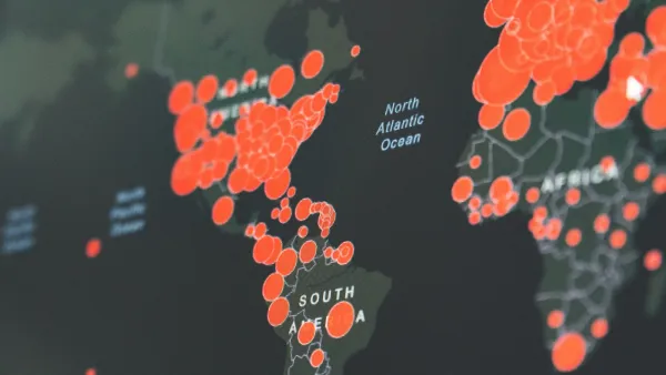
Visualizing the Coronavirus Pandemic
Mapping of the crisis is producing a fascinating and important trove of cartographic records.

New Book Shows How Geographic Technology Tackles Global Challenges
In his new book, Jack Dangermond explores the transformative impact of GIS technology in solving global challenges through spatial data, highlighting its widespread application across sectors and its potential to design sustainable futures.

National Parks Layoffs Will Cause Communities to Lose Billions
Thousands of essential park workers were laid off this week, just before the busy spring break season.

Retro-silient?: America’s First “Eco-burb,” The Woodlands Turns 50
A master-planned community north of Houston offers lessons on green infrastructure and resilient design, but falls short of its founder’s lofty affordability and walkability goals.

Delivering for America Plan Will Downgrade Mail Service in at Least 49.5 Percent of Zip Codes
Republican and Democrat lawmakers criticize the plan for its disproportionate negative impact on rural communities.

Test News Post 1
This is a summary

Test News Headline 46
Test for the image on the front page.

Balancing Bombs and Butterflies: How the National Guard Protects a Rare Species
The National Guard at Fort Indiantown Gap uses GIS technology and land management strategies to balance military training with conservation efforts, ensuring the survival of the rare eastern regal fritillary butterfly.
Urban Design for Planners 1: Software Tools
This six-course series explores essential urban design concepts using open source software and equips planners with the tools they need to participate fully in the urban design process.
Planning for Universal Design
Learn the tools for implementing Universal Design in planning regulations.
EMC Planning Group, Inc.
Planetizen
Planetizen
Mpact (formerly Rail~Volution)
Great Falls Development Authority, Inc.
HUDs Office of Policy Development and Research
NYU Wagner Graduate School of Public Service