


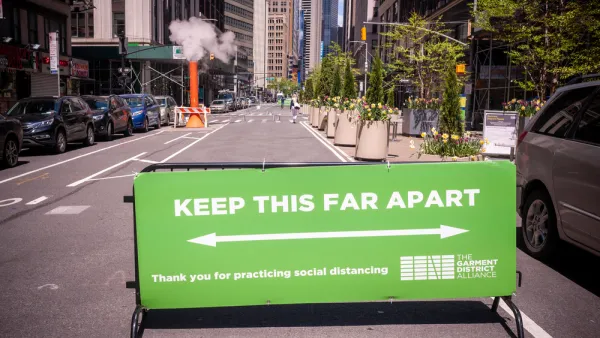
New York City has opened an increasing number of street miles for pedestrians and people on bikes, but far fewer streets have been opened in the neighborhoods that need it most—low income neighborhoods lacking walkable access to parks and open space.
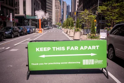
"Public space for social distancing is hard to find in many of New York City’s low-income neighborhoods," reports Clayton Guse.
That conclusion is made possible by a map published recently by the Trust for Public Land. "The map reveals inequities in Mayor de Blasio’s move to open up 30 miles of streets for pedestrians during the coronavirus pandemic," according to Guse.
The map overlays the open streets opening in New York City, overlaid on a map of walkable proximity to park and open space. "Neighborhoods like Brownsville in Brooklyn and Elmhurst in Queens contain large swaths that are more than a 10-minute walk from an open public park," explains Guse. "But parts of those neighborhoods have been left out of the city’s plan to ban cars from some streets as a relief valve for people on foot."
On May 22, a day after the TPL map was published, New York City announced 13 new miles of open streets and claimed to have the most miles of open streets of any city in the country, according to an article by Gersh Kuntzman.
FULL STORY: De Blasio’s move to open NYC street to pedestrians leaves out low-income neighborhoods, map shows

How Oakland Is Fixing its Pandemic Planning Equity Problem
The Oakland Slow Streets program, one of the most controversial developments of the early pandemic, has evolved to become the Essential Places initiative, thanks to new planning practices and a commitment to equity in Oakland, California.

New York Outdoor Dining, Open Streets Programs Now Permanent
New York City will now be measurably less car-centric for the indefinite future.
Pandemic Planning Must Reconcile With the Inequities of the Past
The ongoing debate about the role of marginalized communities in the emergency planning programs of the pandemic has now been detailed on the pages of the New York Times.

National Parks Layoffs Will Cause Communities to Lose Billions
Thousands of essential park workers were laid off this week, just before the busy spring break season.

Retro-silient?: America’s First “Eco-burb,” The Woodlands Turns 50
A master-planned community north of Houston offers lessons on green infrastructure and resilient design, but falls short of its founder’s lofty affordability and walkability goals.

Delivering for America Plan Will Downgrade Mail Service in at Least 49.5 Percent of Zip Codes
Republican and Democrat lawmakers criticize the plan for its disproportionate negative impact on rural communities.

Test News Post 1
This is a summary

Test News Headline 46
Test for the image on the front page.

Balancing Bombs and Butterflies: How the National Guard Protects a Rare Species
The National Guard at Fort Indiantown Gap uses GIS technology and land management strategies to balance military training with conservation efforts, ensuring the survival of the rare eastern regal fritillary butterfly.
Urban Design for Planners 1: Software Tools
This six-course series explores essential urban design concepts using open source software and equips planners with the tools they need to participate fully in the urban design process.
Planning for Universal Design
Learn the tools for implementing Universal Design in planning regulations.
EMC Planning Group, Inc.
Planetizen
Planetizen
Mpact (formerly Rail~Volution)
Great Falls Development Authority, Inc.
HUDs Office of Policy Development and Research
NYU Wagner Graduate School of Public Service