


Montgomery County planners recommend the implementation of sidewalks, crosswalks, and bike lanes on streets within a half-mile radius of Purple Line light-rail stations.
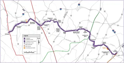
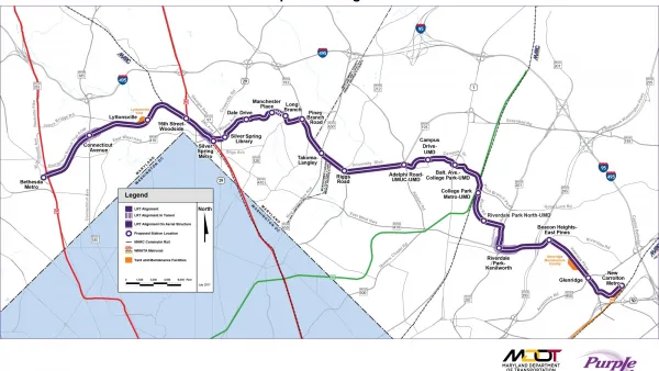
According to a new study conducted by planners in Montgomery County, Maryland, suburban streets surrounding Purple Line stations need improved sidewalks and crosswalks to allow safer access for pedestrians. Purple Line riders are expected to access the train primarily on foot as the stations are designed to utilize only existing parking infrastructure. "With most Purple Line passengers expected to reach stations by walking, in addition to bus, making surrounding roads more comfortable for pedestrians will be key to their safety and willingness to use the new light-rail system," reports Katherine Shaver.
Within a half-mile radius of the ten Purple Line stations in the county, planners found that most streets have too narrow or no sidewalks as well as a similar lack of marked crosswalks. Shaver says the planners recommend a speed reduction from 30-40 mph to 25 mph within the half-mile radius from stations. Improving the pedestrian-friendliness of the streets in the car-dominated suburbs will include widening sidewalks, adding bike lanes, increasing visibility of crosswalks, and landscaping to create a buffer between cars and pedestrians. Shaver says "planners recommend prioritizing improvements in communities with lower household incomes and more minority residents because they have some of the most dangerous walking conditions and have been underserved historically."
FULL STORY: Purple Line stations need safer access for pedestrians, planners say

Maryland's Purple Line Gets the Green Light Again
The public-private partnership behind the Purple Line light rail project in Maryland fell apart in September, and has this past week been revived.
Purple Line Construction Halts in Maryland as Contractor Woes Deepen
Purple Line Transit Partners, the contractors managing construction of the beleaguered Purple Line in Maryland, have begun to walk off the job as a dispute about cost overruns brings the project to a screeching halt.
Preserving Affordable Housing Along Maryland Light Rail Line
A new plan lays out strategies to keep housing affordable for low- and moderate-income residents along the corridor of Maryland’s new Purple Line.

National Parks Layoffs Will Cause Communities to Lose Billions
Thousands of essential park workers were laid off this week, just before the busy spring break season.

Retro-silient?: America’s First “Eco-burb,” The Woodlands Turns 50
A master-planned community north of Houston offers lessons on green infrastructure and resilient design, but falls short of its founder’s lofty affordability and walkability goals.

Delivering for America Plan Will Downgrade Mail Service in at Least 49.5 Percent of Zip Codes
Republican and Democrat lawmakers criticize the plan for its disproportionate negative impact on rural communities.

Test News Post 1
This is a summary

Test News Headline 46
Test for the image on the front page.

Balancing Bombs and Butterflies: How the National Guard Protects a Rare Species
The National Guard at Fort Indiantown Gap uses GIS technology and land management strategies to balance military training with conservation efforts, ensuring the survival of the rare eastern regal fritillary butterfly.
Urban Design for Planners 1: Software Tools
This six-course series explores essential urban design concepts using open source software and equips planners with the tools they need to participate fully in the urban design process.
Planning for Universal Design
Learn the tools for implementing Universal Design in planning regulations.
EMC Planning Group, Inc.
Planetizen
Planetizen
Mpact (formerly Rail~Volution)
Great Falls Development Authority, Inc.
HUDs Office of Policy Development and Research
NYU Wagner Graduate School of Public Service