


The National Highway Safety Administration released traffic safety data finding a huge spike in fatalities since the outset of the pandemic, but didn't mention the role of street design in traffic fatalities.
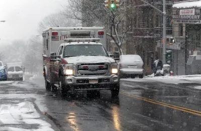
"The rate of roadway fatalities skyrocketed to 1.42 deaths per 100 million vehicle miles traveled in the second quarter of 2020, according to the National Highway Safety Administration’s just-released report," reports Kea Wilson.
The report makes officials news that has been apparent since the beginning of the pandemic: that drivers are more reckless and dangerous since stay-at-home orders and social distancing emptied roads of cars around the country.
The 1.42 deaths per 100 million vehicles miles traveled represents a 32 percent increase over the 1.08 deaths per 100 million vehicle miles traveled reported for the same period last year.
"With so many fewer cars on the road, the raw number of deadly crashes did decrease during the height of quarantine orders, but not by very much," writes Wilson. "NHTSA reports that 8,870 people lost their lives on U.S. roadways between April and June of this year — just a 3.3-percent decrease over the same period last year, despite declines of driving of as much as 94 percent in many areas of the country."
In an exclusive interview with Reuters, a spokesperson for the NHSTA blamed drivers for risky behavior, but Wilson expresses dismay that "the federal agency blamed the bloodshed on everything but bad road design."
FULL STORY: Road Fatality Rates Reach Highest Level in 15 Years

Traffic Fatalities Set Records as Pandemic-Era Road Carnage Shows No Signs of Stopping
An estimated 42,915 people died in automobile crashes in 2021, according to recent federal data. The increasing fatalities continue a trend that began with the outset of the pandemic.

Experts Fear a Permanent 'Arousal Breakout' on U.S. Roadways
The reckless and dangerous driving that has been a hallmark of the Covid-19 pandemic could become a more common, permanent feature of life in the United States.
The Most Complete Map of U.S. Pedestrian Risk Yet
New research published by the Journal of Transport and Land Use analyzes tens of thousands of pedestrian fatalities over 16 years in the United States.

National Parks Layoffs Will Cause Communities to Lose Billions
Thousands of essential park workers were laid off this week, just before the busy spring break season.

Retro-silient?: America’s First “Eco-burb,” The Woodlands Turns 50
A master-planned community north of Houston offers lessons on green infrastructure and resilient design, but falls short of its founder’s lofty affordability and walkability goals.

Delivering for America Plan Will Downgrade Mail Service in at Least 49.5 Percent of Zip Codes
Republican and Democrat lawmakers criticize the plan for its disproportionate negative impact on rural communities.

Test News Post 1
This is a summary

Test News Headline 46
Test for the image on the front page.

Balancing Bombs and Butterflies: How the National Guard Protects a Rare Species
The National Guard at Fort Indiantown Gap uses GIS technology and land management strategies to balance military training with conservation efforts, ensuring the survival of the rare eastern regal fritillary butterfly.
Urban Design for Planners 1: Software Tools
This six-course series explores essential urban design concepts using open source software and equips planners with the tools they need to participate fully in the urban design process.
Planning for Universal Design
Learn the tools for implementing Universal Design in planning regulations.
EMC Planning Group, Inc.
Planetizen
Planetizen
Mpact (formerly Rail~Volution)
Great Falls Development Authority, Inc.
HUDs Office of Policy Development and Research
NYU Wagner Graduate School of Public Service