


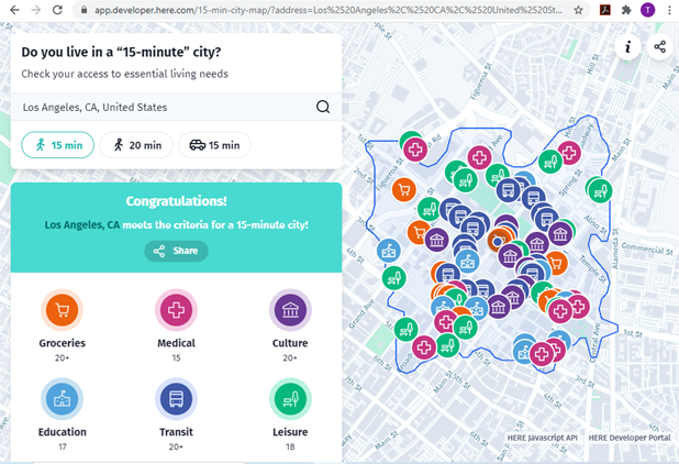
The new 15-Minute City App generates maps which show the number of services and activities within a 15 minute walk, and and therefore whether an area can be considered a 15-minute neighborhood.

A 15-min city, or “la ville du quart d’heure” refers to an urban neighborhood where all the essential needs can be accessed within a 15 minute walk or bike ride. This is a practical way to evaluate multi-modal accessibility, that is, the ease of living without a car, and therefore whether a neighborhood is affordable, equitable, healthy and resource-efficient.
The new 15-Minute City App generates maps for U.S. addresses which show the number of medical centers, grocery stores, cultural attractions, transit stops, education facilities and leisure spots that can be reached within a 15 or 20 minute walk, and therefore whether it can be considered to be in a 15-minute neighborhood.
Real estate agents and developers pay attention: consumer preference surveys indicate that most households want to live in walkable neighborhoods, resulting in a shortage of such housing. Let's build lots more!
FULL STORY: Do you live in a “15-minute” city?


Analyzing Accessibility Disparities
With better planning we can reduce disparities between drivers and non-drivers in their ability to access services and jobs, improving fairness and economic opportunities for disadvantaged groups.
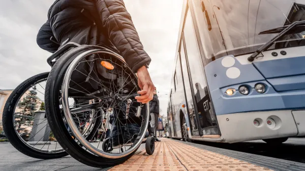
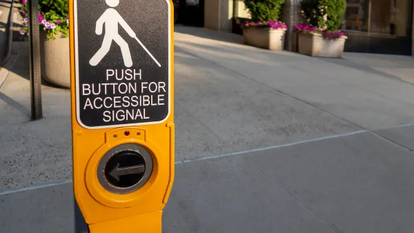
Commentary: Avoiding Ableism in 15-Minute Cities
One author calls on planners to challenge assumptions that exclude people with mobility challenges and other disabilities.
Accessibility and Car-Free Zones
Some critics of car-free zones call them exclusionary to people with disabilities, but other experts argue that, when properly planned, pedestrian enhancements improve safety and accessibility for everyone.

National Parks Layoffs Will Cause Communities to Lose Billions
Thousands of essential park workers were laid off this week, just before the busy spring break season.

Retro-silient?: America’s First “Eco-burb,” The Woodlands Turns 50
A master-planned community north of Houston offers lessons on green infrastructure and resilient design, but falls short of its founder’s lofty affordability and walkability goals.

Delivering for America Plan Will Downgrade Mail Service in at Least 49.5 Percent of Zip Codes
Republican and Democrat lawmakers criticize the plan for its disproportionate negative impact on rural communities.

Test News Post 1
This is a summary

Test News Headline 46
Test for the image on the front page.

Balancing Bombs and Butterflies: How the National Guard Protects a Rare Species
The National Guard at Fort Indiantown Gap uses GIS technology and land management strategies to balance military training with conservation efforts, ensuring the survival of the rare eastern regal fritillary butterfly.
Urban Design for Planners 1: Software Tools
This six-course series explores essential urban design concepts using open source software and equips planners with the tools they need to participate fully in the urban design process.
Planning for Universal Design
Learn the tools for implementing Universal Design in planning regulations.
EMC Planning Group, Inc.
Planetizen
Planetizen
Mpact (formerly Rail~Volution)
Great Falls Development Authority, Inc.
HUDs Office of Policy Development and Research
NYU Wagner Graduate School of Public Service