


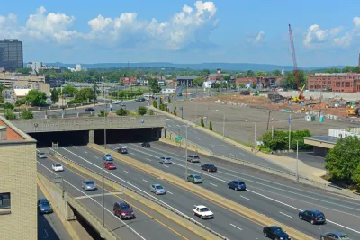
A new plan would spend an estimated $17 billion to remove a huge chunk of the Interstate Highway System's footprint in Hartford, Connecticut.
Tom Condon reports on an ambitious new plan to recover some of what was lost when interstate freeways were built through the city six decades ago.
First, the historical context:
Decades ago, the construction of I-91 cut Hartford off from the Connecticut River. I-84 isolated the North End from downtown and consumed a large swath of land and many historic buildings, including the majestic Hartford Public High School campus. The interchange of the two highways laid waste to part of the central business district.
East Hartford wasn’t spared; its massive “mixmaster” interchange occupies an area the size of downtown Hartford.
Two plans have attempted to rectify the damage from these decisions in the past decade, according to Condon, but neither made much progress. But a new plan, emerging as a hybrid of the previous ideas, has emerged.
"The new plan is part of a regional planning effort called Hartford 400, initiated by the iQuilt project in Hartford. It envisions a roughly triangular ring road around the downtown, with some tunneling but much less than Larson proposed, and new connections to East Hartford," according to Condon. The project would cost an estimated $17 billion, but the results would include removing the I-84/I-91 and "mixmaster" interchanges, freeing up more than 150 acres of "prime urban land" for development. In addition, the plan would also cap I-91 through downtown Hartford.
The article includes more details about the iQuilt Partnership, the brainchild of Hartford native and Los Angeles-based urban planner, Doug Suisman.
FULL STORY: There’s a new plan for realigning Hartford’s highways. Is the third time the charm?


The Foundational Myth of America's Interstate Highway System
The erroneous belief that the negative impacts of interstate highways are simply "unintended consequences" fails to demand accountability for the project's failures.
Economic Justice Includes Highway Removals
A $435 billion "economic justice" bill proposed by Democrats in the U.S. Senate includes $10 billion for projects that remove highways and build community-oriented assets in their place.
The Deliberate Segregation of U.S. Cities, as Evidenced by Freeway Congestion
A thorough and damning indictment of 20th century land use and infrastructure planning, and its contemporary legacy of segregation and congestion.

National Parks Layoffs Will Cause Communities to Lose Billions
Thousands of essential park workers were laid off this week, just before the busy spring break season.

Retro-silient?: America’s First “Eco-burb,” The Woodlands Turns 50
A master-planned community north of Houston offers lessons on green infrastructure and resilient design, but falls short of its founder’s lofty affordability and walkability goals.

Delivering for America Plan Will Downgrade Mail Service in at Least 49.5 Percent of Zip Codes
Republican and Democrat lawmakers criticize the plan for its disproportionate negative impact on rural communities.

Test News Post 1
This is a summary

Test News Headline 46
Test for the image on the front page.

Balancing Bombs and Butterflies: How the National Guard Protects a Rare Species
The National Guard at Fort Indiantown Gap uses GIS technology and land management strategies to balance military training with conservation efforts, ensuring the survival of the rare eastern regal fritillary butterfly.
Urban Design for Planners 1: Software Tools
This six-course series explores essential urban design concepts using open source software and equips planners with the tools they need to participate fully in the urban design process.
Planning for Universal Design
Learn the tools for implementing Universal Design in planning regulations.
EMC Planning Group, Inc.
Planetizen
Planetizen
Mpact (formerly Rail~Volution)
Great Falls Development Authority, Inc.
HUDs Office of Policy Development and Research
NYU Wagner Graduate School of Public Service