


A Story Map created by the Louisville Metro Office of Planning & Design Services offers a detailed, visual presentation of the history of racism and discriminatory in the planning and zoning of the Louisville and Jefferson County.
The Louisville Metro Office of Planning & Design Services has created a Story Map titled "Confronting Racism in City Planning & Zoning" and published it online for public viewing.
The Story Map describes past land use and housing practices as discriminatory and inequitable and offers a clear and direct reply to those who question the racist and discriminatory intentions of previous eras of planning history (in addition to the legacies of those intentions in the present day).
The Louisville Metro Office of Planning & Design Services, with support from Louisville Metro Council, Mayor Greg Fischer, and the Louisville Metro Planning Commission, is reviewing the Land Development Code (LDC) "to identify and address land use regulations and policies that have inequitable impacts on Louisville residents," according to the Story Map.
After providing an introduction of zoning and the recent planning efforts that define the vision for Louisville's future (e.g., the Louisville Metro Comprehensive Plan: PLAN 2040 that took effect on January 1, 2019), the Story Map notes Louisville's central role in the early history of explicitly racist planning by reviewing Louisville's 1914 racial segregation ordinance and the ensuing Supreme Court ruling in Buchanan v. Warley (1917) as well as providing a summary of The Man at the Center: Harland Bartholomew.
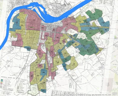
A long, detailed history of plans and zoning regulations specific to Louisville history follows, with attention to benchmarks in Louisville history like the 1931 Comprehensive Plan, the 1958 Comprehensive Plan, and zoning regulations applied uniformly to both the city and county in 1963.
"The minimum lot size or the area of land needed for a single-family home within the predominate zoning district in Louisville-Jefferson County has been minimally revised since Louisville's first zoning ordinance in 1931, and unchanged since 1963. Restricting the minimum lot size has limited housing choice and affordability," according to the Story Map, for an example of the hard truths laid out here with clear documentation and visual perspective.
The Story Map concludes with attention to the city's ongoing efforts to reform its Land Development Code (LDC) with these perspectives in mind. Planning consultants Opticos Design recently completed a "diagnosis" of the LDC, which is available online. The Story Map was included in an article published online by Planning magazine that lists six ways to "help bridge the racial wealth gap." In recent years, the metro Louisville government has made repeated efforts to confront the racism in its planning and development history, such as with the "Redlining Louisville: The History of Race, Class, and Real Estate" map created by the Louisville Office of Redevelopment Strategies in 2017.
FULL STORY: Confronting Racism in Zoning


History (Un)made: Berkeley City Council Votes to Eliminate Single-Family Zoning
The city that invented single-family zoning in 1916, for discriminatory purposes, will completely remove that exclusionary legacy from its zoning code.

Exclusionary Zoning and Poverty: A New Hampshire Case Study
A deep dive into the history of zoning and development in Manchester, New Hampshire.

White House Marks Juneteenth by Pushing for Zoning Reforms
On a holiday that commemorates the end of slavery in the United States, the White House marked the occasion by discussion exclusionary zoning.

National Parks Layoffs Will Cause Communities to Lose Billions
Thousands of essential park workers were laid off this week, just before the busy spring break season.

Retro-silient?: America’s First “Eco-burb,” The Woodlands Turns 50
A master-planned community north of Houston offers lessons on green infrastructure and resilient design, but falls short of its founder’s lofty affordability and walkability goals.

Delivering for America Plan Will Downgrade Mail Service in at Least 49.5 Percent of Zip Codes
Republican and Democrat lawmakers criticize the plan for its disproportionate negative impact on rural communities.

Test News Post 1
This is a summary

Test News Headline 46
Test for the image on the front page.

Balancing Bombs and Butterflies: How the National Guard Protects a Rare Species
The National Guard at Fort Indiantown Gap uses GIS technology and land management strategies to balance military training with conservation efforts, ensuring the survival of the rare eastern regal fritillary butterfly.
Urban Design for Planners 1: Software Tools
This six-course series explores essential urban design concepts using open source software and equips planners with the tools they need to participate fully in the urban design process.
Planning for Universal Design
Learn the tools for implementing Universal Design in planning regulations.
EMC Planning Group, Inc.
Planetizen
Planetizen
Mpact (formerly Rail~Volution)
Great Falls Development Authority, Inc.
HUDs Office of Policy Development and Research
NYU Wagner Graduate School of Public Service