


Plans for the area include thousands of new housing units, public parks, and improved bike and pedestrian infrastructure.
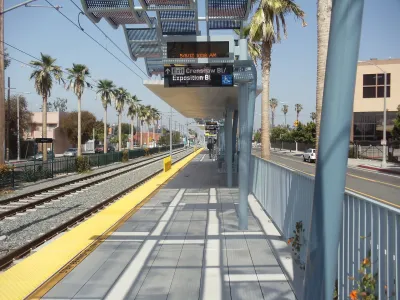
As the Crenshaw rail line reaches completion, the city of Inglewood is considering changes to its zoning regulations "which would permit the construction of new homes, offices, and retail near passenger rail stops on Metro's Crenshaw/LAX and C Lines," reports Steven Sharp in Urbanize Los Angeles. The Westchester/Veterans and Crenshaw/Imperial TOD (Transit Oriented Development) Plans "would impact land use regulations for roughly 650 acres of land at Inglewood's northwest corner adjacent to the Westchester neighborhood and at its southern border with the City of Hawthorne," adding up to 4,090 new homes, 705,000 square feet of commercial space, and 5,684 new jobs. The plans also include new cycletracks, improved pedestrian mobility, and new public parks.
Local leaders hope the construction of the new Crenshaw Line, which was originally scheduled to open in 2019, will provide new transit options for workers in the area and boost economic activity in the area. "The City has already adopted new zoning for its Downtown and Fairview Heights neighborhoods, which also sit along the transit line's route."
"Implementation of the visions detailed in the TOD plans will require multiple discretionary approvals, both by the city of Inglewood and other entities, such as the city of Hawthorne and Caltrans. A draft environmental impact report is now being circulated for review."
FULL STORY: Inglewood considers new zoning near Crenshaw/LAX and C Line stations


NoHo and SoHo Rezoning Controversies, Amplified
One of the big questions of planning is up for debate with a proposed rezoning in the SoHo and NoHo neighborhoods of New York City: Can upzoning be an effective tool for affordability?

Silver Spring Downtown Plan Expanding to Make Room for the Missing Middle
Planners are hoping that by expanding the boundaries of the Silver Spring Downtown Plan in Montgomery County, Maryland, new opportunities for missing middle housing will create new opportunities for housing affordability.

A Transit and Land Use Planning Shift in Federal Way, Washington
Federal funding for Sound Transit's Federal Way Link extension and a new transit-oriented land use plan are changing the future of Federal Way.

National Parks Layoffs Will Cause Communities to Lose Billions
Thousands of essential park workers were laid off this week, just before the busy spring break season.

Retro-silient?: America’s First “Eco-burb,” The Woodlands Turns 50
A master-planned community north of Houston offers lessons on green infrastructure and resilient design, but falls short of its founder’s lofty affordability and walkability goals.

Delivering for America Plan Will Downgrade Mail Service in at Least 49.5 Percent of Zip Codes
Republican and Democrat lawmakers criticize the plan for its disproportionate negative impact on rural communities.

Test News Post 1
This is a summary

Test News Headline 46
Test for the image on the front page.

Balancing Bombs and Butterflies: How the National Guard Protects a Rare Species
The National Guard at Fort Indiantown Gap uses GIS technology and land management strategies to balance military training with conservation efforts, ensuring the survival of the rare eastern regal fritillary butterfly.
Urban Design for Planners 1: Software Tools
This six-course series explores essential urban design concepts using open source software and equips planners with the tools they need to participate fully in the urban design process.
Planning for Universal Design
Learn the tools for implementing Universal Design in planning regulations.
EMC Planning Group, Inc.
Planetizen
Planetizen
Mpact (formerly Rail~Volution)
Great Falls Development Authority, Inc.
HUDs Office of Policy Development and Research
NYU Wagner Graduate School of Public Service