


As sea levels rise, California's coastal communities face difficult decisions about how to preserve coastlines and mitigate the looming threat.
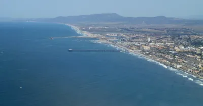
"Whether the width of the beach is shrinking due to climate change and rising sea levels, coastal development or both, the fact of the matter is: Oceanside, like many of Southern California coastal communities, is struggling to protect its beachfront properties." Now, as MacKenzie Elmer reports in Voice of San Diego, a tense debate between city officials and the California Coastal Commission "is adding fuel to a larger debate over what Oceanside should do about its shrinking coastline."
Unlike other California cities, "allows property owners to do certain types of repair work to their boulder walls – called revetments – without having to get a coastal development permit," but "[t]he city restricts how much, what type and where material can be placed, and Oceanside’s engineering staff reviews the plans to make sure they follow wall-design standards." However, a lack of proactive enforcement means that work frequently happens without city approval, including illegal practices like pouring concrete between the boulders.
"But there’s a bigger issue at stake than permitting maintenance work. The city of Oceanside is updating what’s known as a Local Coastal Program, which spells out the types of development and projects that need Coastal Commission permission. The Coastal Commission also needs to sign off on any city’s Local Coastal Program. Oceanside is also working through its own assessment of how climate change is going to shrink the beach and endanger coastal homes down the line, a process that involves studying how to add and keep sand on the beach." Although not yet on the table in Oceanside, some coastal communities are evaluating plans for "managed retreat" as rising waters and erosion threaten coastal development.
FULL STORY: Oceanside Seawall Dispute Hints at Looming Decisions Over Sea-Level Rise

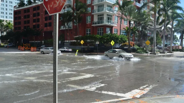
Miami Residents Resist the Idea of a 20-Foot Seawall
As climate change accelerates sea level rise and flooding in South Florida, locals hope to mitigate the impacts with less dramatic interventions.
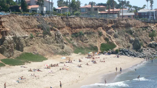
Coastal City Rejects 'Managed Retreat' Strategy
Del Mar, in Southern California, says it does not want to adopt the approach as part of its sea-level rise adaptation plan.
Protecting California's Coastal Development Will Cost Billions
Computer modeling predicts sea levels rising 55 inches by 2100, and a recent report from California's interagency Climate Action Team is calling for a radical reorganization of the state's coastal development and infrastructure to avoid disaster.

National Parks Layoffs Will Cause Communities to Lose Billions
Thousands of essential park workers were laid off this week, just before the busy spring break season.

Retro-silient?: America’s First “Eco-burb,” The Woodlands Turns 50
A master-planned community north of Houston offers lessons on green infrastructure and resilient design, but falls short of its founder’s lofty affordability and walkability goals.

Delivering for America Plan Will Downgrade Mail Service in at Least 49.5 Percent of Zip Codes
Republican and Democrat lawmakers criticize the plan for its disproportionate negative impact on rural communities.

Test News Post 1
This is a summary

Test News Headline 46
Test for the image on the front page.

Balancing Bombs and Butterflies: How the National Guard Protects a Rare Species
The National Guard at Fort Indiantown Gap uses GIS technology and land management strategies to balance military training with conservation efforts, ensuring the survival of the rare eastern regal fritillary butterfly.
Urban Design for Planners 1: Software Tools
This six-course series explores essential urban design concepts using open source software and equips planners with the tools they need to participate fully in the urban design process.
Planning for Universal Design
Learn the tools for implementing Universal Design in planning regulations.
EMC Planning Group, Inc.
Planetizen
Planetizen
Mpact (formerly Rail~Volution)
Great Falls Development Authority, Inc.
HUDs Office of Policy Development and Research
NYU Wagner Graduate School of Public Service