


The largest infrastructure project in D.C. history is opening this week—first to pedestrians and then to automobile traffic.
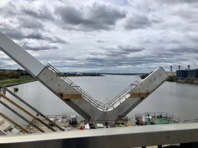
Luz Lazo and Michael Laris report on the debut of the new Frederick Douglass Memorial Bridge, which opened to the public on September 6 and replaced a 71-year-old bridge spanning the Anacostia River in Washington, D.C.
The new bridge is 1,445 feet long and cost $480 million—that latter figure making the new bridge the largest infrastructure project in the history of the District.
"The bridge is not finished. Vises hold up 2-by-4s as makeshift barriers on concrete lookout areas, and paving and connections aren’t complete on wide pedestrian pathways. But Monday’s bridge celebration — starting with a 5K run and walk led by Mayor Muriel E. Bowser — offered expansive views and the chance for many to consider a changing city," according to the article.
Vehicle traffic is expected to start crossing the bridge on Friday and Saturday of this week. "Runners, walkers and stroller-pushers began crossing the span about 9 a.m. Monday as an American flag waved from one of its towering white arches."
The article includes anecdotes and soundbites from the bridges debut on Labor Day. Lazo and Laris also sum up the relevance of the bridge's reopening relative to the larger cultural context and planning history of the District thusly:
The opening of the distinct structure with parallel arcs marks a milestone in the vision to turn the South Capitol Street Corridor into the grand boulevard that Pierre L’Enfant envisioned in his original plan for the nation’s capital. L’Enfant identified the corridor as a symbolic gateway into the District’s monumental core, one that has not been realized as the road maintained a freeway-type configuration that lacked adequate pedestrian and cycling facilities.
FULL STORY: New $480 million Frederick Douglass Memorial Bridge begins opening week with a Labor Day celebration

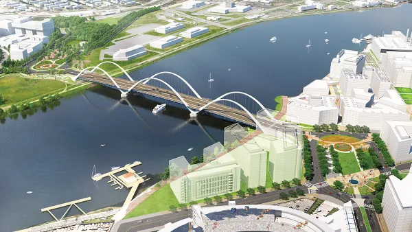
Iconic New Bridge Project Revealed in D.C.
The new Frederick Douglass Memorial Bridge will span the Anacostia River between Washington, D.C. and Anacostia.
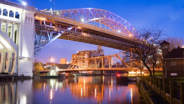
Defunct Streetcar Bridge Could Become Cleveland’s ‘Low Line’
The city will develop a plan to transform an unused streetcar deck on the Veterans Memorial Bridge into a connector for bikes and pedestrians as well as a welcoming public space.
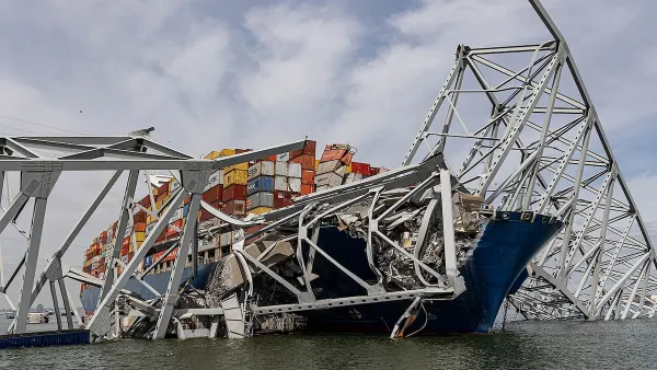
Baltimore Traffic Suffering From Absence of Key Bridge
The loss of a key route to the Port of Baltimore is causing major delays and long detours on alternate routes.

National Parks Layoffs Will Cause Communities to Lose Billions
Thousands of essential park workers were laid off this week, just before the busy spring break season.

Retro-silient?: America’s First “Eco-burb,” The Woodlands Turns 50
A master-planned community north of Houston offers lessons on green infrastructure and resilient design, but falls short of its founder’s lofty affordability and walkability goals.

Delivering for America Plan Will Downgrade Mail Service in at Least 49.5 Percent of Zip Codes
Republican and Democrat lawmakers criticize the plan for its disproportionate negative impact on rural communities.

Test News Post 1
This is a summary

Test News Headline 46
Test for the image on the front page.

Balancing Bombs and Butterflies: How the National Guard Protects a Rare Species
The National Guard at Fort Indiantown Gap uses GIS technology and land management strategies to balance military training with conservation efforts, ensuring the survival of the rare eastern regal fritillary butterfly.
Urban Design for Planners 1: Software Tools
This six-course series explores essential urban design concepts using open source software and equips planners with the tools they need to participate fully in the urban design process.
Planning for Universal Design
Learn the tools for implementing Universal Design in planning regulations.
EMC Planning Group, Inc.
Planetizen
Planetizen
Mpact (formerly Rail~Volution)
Great Falls Development Authority, Inc.
HUDs Office of Policy Development and Research
NYU Wagner Graduate School of Public Service