


Using zoning codes to improve accessibility to public transit facilities is a new, but well overdue, idea.
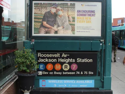
The challenge of retrofitting contemporary standards of access for people with disabilities on a subway system well over a century old has long troubled New York City. Now there's a new tool in effort that's about as old as the subway: zoning.
"Mayor Bill de Blasio, the New York City Council and the Metropolitan Transportation Authority (MTA) have announced the approval of Elevate Transit: Zoning for Accessibility, a collaboration between the MTA, City Council, the Department of City Planning (DCP) and the Mayor’s Office for People with Disabilities (MOPD) to boost New York City’s push to make its transit system fully accessible," according to an article published by the Intelligent Transport website.
"The initiative will allow the MTA to leverage planned private development to achieve a fully accessible transit system faster, while saving taxpayer dollars as the MTA faces financial challenges caused by the ongoing pandemic."
Elevate Transit both creates new zoning tools and strengthens existing zoning tools to incorporate public transit accessibility into private real estate developments. The MTA committed to spending $600 million on accessibility in 2018, eventually raising that number to a total $5 billion investment for accessibility improvements on the subway, the Long Island Rail Road, Metro-North Railroad, and the Staten Island Railway as part of its 2020 – 2024 Capital Program.
As for more specifics, the article includes the following:
- "This provision requires developers of most mid- or high-density sites adjacent to subway, Staten Island Railway, Long Island Rail Road and Metro-North Railroad stations within New York City to consult with the MTA first to determine whether the MTA needs an easement (permanent access to a small piece of property) for future accessibility projects at the adjacent station."
- "This provision expands the existing ‘transit improvement bonus’ from central business districts to other high-density areas in the city. This programme incentivises private developers to directly fund and build new transit station access improvements, such as elevators or other circulation improvements at already accessible stations, in exchange for a floor area bonus of up to 20 per cent."
FULL STORY: NEWS NYC’s Elevate Transit: Zoning for Accessibility initiative receives approval

New Zoning Incentives for Grocery Store Developments Proposed in New York City
Transit accessibility incentives are also included in a package of zoning reforms proposed this week that would provide incentives for grocery store developments in a wider swath of New York City.
New York Subway Begins Accessibility Improvements
The MTA is putting its effort to improve the system’s century-old stations to make them more universally accessible in high gear, adding elevators, boarding upgrades, and mechanical improvements.

New York Must Make Almost All Subway Stations Accessible by 2055, Judge Rules
Another recent ruling is forcing the agency to accelerate its efforts to make all New York subway stations accessible to people with disabilities and mobility issues.

National Parks Layoffs Will Cause Communities to Lose Billions
Thousands of essential park workers were laid off this week, just before the busy spring break season.

Retro-silient?: America’s First “Eco-burb,” The Woodlands Turns 50
A master-planned community north of Houston offers lessons on green infrastructure and resilient design, but falls short of its founder’s lofty affordability and walkability goals.

Delivering for America Plan Will Downgrade Mail Service in at Least 49.5 Percent of Zip Codes
Republican and Democrat lawmakers criticize the plan for its disproportionate negative impact on rural communities.

Test News Post 1
This is a summary

Test News Headline 46
Test for the image on the front page.

Balancing Bombs and Butterflies: How the National Guard Protects a Rare Species
The National Guard at Fort Indiantown Gap uses GIS technology and land management strategies to balance military training with conservation efforts, ensuring the survival of the rare eastern regal fritillary butterfly.
Urban Design for Planners 1: Software Tools
This six-course series explores essential urban design concepts using open source software and equips planners with the tools they need to participate fully in the urban design process.
Planning for Universal Design
Learn the tools for implementing Universal Design in planning regulations.
EMC Planning Group, Inc.
Planetizen
Planetizen
Mpact (formerly Rail~Volution)
Great Falls Development Authority, Inc.
HUDs Office of Policy Development and Research
NYU Wagner Graduate School of Public Service