


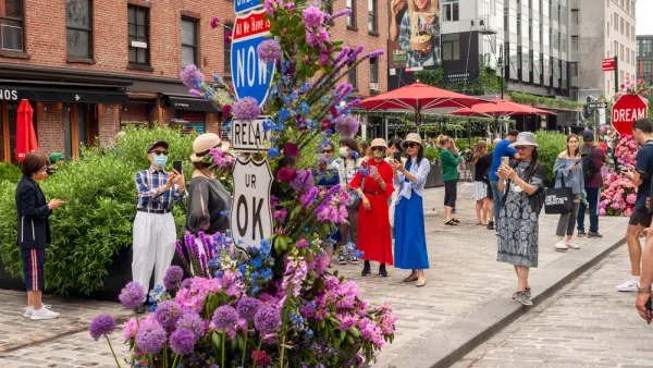
In December 2019, the Downtown Brooklyn Public Realm Vision set ambitious goals for removing cars from one of New York's central business districts. Then came the pandemic and new tests for those ambitions.
Stakeholders in Downtown Brooklyn are building on a 2019 master plan that ranks as one of the most ambitious visions for car-free urbanism in the country.
The Downtown Brooklyn Partnership unveiled the Downtown Brooklyn Public Realm Vision in 2019, inspired in part by recent street redesigns in the city, like the pedestrianization of Times Square and the 14th Street Busway (Benjamin Schneider broke the news of the Public Realm Vision in December 2019).
A new article by John Schneider updates the progress toward achieving the master plan's ambitious vision—which includes a neighborhood network of Dutch-style shared streets, busways, protected bike lanes, and improvements to green spaces.
"It was a pedestrian-centric rebuke of the Robert Moses-era planning that dominates much of the borough, where cars flood wide streets en route to the Brooklyn and Manhattan Bridges," according to Surico.
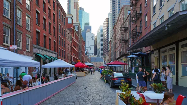
With the pandemic generating unanticipated support for car-free reforms, the Downtown Brooklyn Partnership is hoping to build on that momentum by releasing the Downtown Brooklyn Public Realm Action Plan, a Covid-era update to the original master plan released earlier this month.
"The plan doubles down on the 2019 vision’s calls for pedestrianization, while picking up institutional support and a handful of tangible achievements since then. Not to mention a new streetscape paradigm: This is a city where pandemic-era curbside dining and 'Open Streets' are now permanent fixtures," writes Surico.
As detailed in the source article, linked below, the Downtown Brooklyn is far from alone in its efforts to pedestrianize New York City.
FULL STORY: Downtown Brooklyn’s Greener, Car-Free Future Is Taking Root

The Tide Has Turned Against Open Streets
Once a promising development for advocates pushing for a less car-centric future in cities, the open streets movement has ceded significant ground to cars since the height of the pandemic.
New Car Owners, Fewer Parking Spaces—Chickens Come to Roost in New York City
Many cities like New York have reallocated space formerly reserved for moving and storing cars to help restaurants and stores weather the pandemic, but as more residents rely on cars for the same reason, the dynamic threatens to boil over.
New York Outdoor Dining, Open Streets Programs Now Permanent
New York City will now be measurably less car-centric for the indefinite future.

National Parks Layoffs Will Cause Communities to Lose Billions
Thousands of essential park workers were laid off this week, just before the busy spring break season.

Retro-silient?: America’s First “Eco-burb,” The Woodlands Turns 50
A master-planned community north of Houston offers lessons on green infrastructure and resilient design, but falls short of its founder’s lofty affordability and walkability goals.

Delivering for America Plan Will Downgrade Mail Service in at Least 49.5 Percent of Zip Codes
Republican and Democrat lawmakers criticize the plan for its disproportionate negative impact on rural communities.

Test News Post 1
This is a summary

Test News Headline 46
Test for the image on the front page.

Balancing Bombs and Butterflies: How the National Guard Protects a Rare Species
The National Guard at Fort Indiantown Gap uses GIS technology and land management strategies to balance military training with conservation efforts, ensuring the survival of the rare eastern regal fritillary butterfly.
Urban Design for Planners 1: Software Tools
This six-course series explores essential urban design concepts using open source software and equips planners with the tools they need to participate fully in the urban design process.
Planning for Universal Design
Learn the tools for implementing Universal Design in planning regulations.
EMC Planning Group, Inc.
Planetizen
Planetizen
Mpact (formerly Rail~Volution)
Great Falls Development Authority, Inc.
HUDs Office of Policy Development and Research
NYU Wagner Graduate School of Public Service