


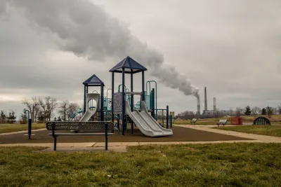
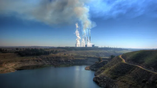
An investigation by ProPublica has produced something the U.S. Environmental Protection Agency has never been able to complete: a nationwide map of the cancer risks created by industrial sources of air pollution.
Al Shaw and Lylla Younes reveal the findings of a new ProPublica analysis into the toxic air pollution emitted into communities around the country.
Here's how Shaw and Younes summarize the investigation and the findings:
ProPublica’s analysis of five years of modeled EPA data identified more than 1,000 toxic hot spots across the country and found that an estimated 250,000 people living in them may be exposed to levels of excess cancer risk that the EPA deems unacceptable.
According to the article, the U.S. Environmental Protection Agency collects data from facilities known to emit large amounts of toxic air pollution, but the agency has never released thus data.
To finally publishing this data for public consumption, the source article (also linked below) maps cancer risk from industrial pollution.
The big, interactive coverage of the investigation also includes a separate article, credited to Younes and Shaw in addition to Lisa Song and Maya Miller. Here's how that article summarizes the stakes of the data revealed by the investigation:
From the urban sprawl of Houston to the riverways of Virginia, air pollution from industrial plants is elevating the cancer risk of an estimated quarter of a million Americans to a level the federal government considers unacceptable.
FULL STORY: The Most Detailed Map of Cancer-Causing Industrial Air Pollution in the U.S.

The Trump Administration's Environmental Policies Have Consequences for Black Lives
A Trump administration decision not to tighten Clean Air Act restrictions on soot pollution will have more consequences for Black Americans.

EPA Relaxes Environmental Rules, Cites Coronavirus
During the outbreak, the agency will allow companies to monitor themselves for pollution violations.

U.S. Air Quality Declining, Taking Lives
Particulate matter air pollution has been on the rise since 2017, according to new research. Wildfires, economic activity, and lax regulation are potentially to blame.

National Parks Layoffs Will Cause Communities to Lose Billions
Thousands of essential park workers were laid off this week, just before the busy spring break season.

Retro-silient?: America’s First “Eco-burb,” The Woodlands Turns 50
A master-planned community north of Houston offers lessons on green infrastructure and resilient design, but falls short of its founder’s lofty affordability and walkability goals.

Delivering for America Plan Will Downgrade Mail Service in at Least 49.5 Percent of Zip Codes
Republican and Democrat lawmakers criticize the plan for its disproportionate negative impact on rural communities.

Test News Post 1
This is a summary

Test News Headline 46
Test for the image on the front page.

Balancing Bombs and Butterflies: How the National Guard Protects a Rare Species
The National Guard at Fort Indiantown Gap uses GIS technology and land management strategies to balance military training with conservation efforts, ensuring the survival of the rare eastern regal fritillary butterfly.
Urban Design for Planners 1: Software Tools
This six-course series explores essential urban design concepts using open source software and equips planners with the tools they need to participate fully in the urban design process.
Planning for Universal Design
Learn the tools for implementing Universal Design in planning regulations.
EMC Planning Group, Inc.
Planetizen
Planetizen
Mpact (formerly Rail~Volution)
Great Falls Development Authority, Inc.
HUDs Office of Policy Development and Research
NYU Wagner Graduate School of Public Service