


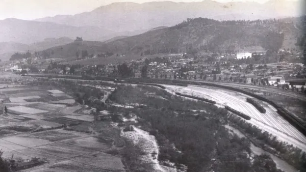
New park spaces to meet the needs of underserved communities are being planned along the Los Angeles River.
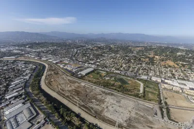
The "100-Acre Partnership at Taylor Yard" has been formed to coordinate and collaborate in planning the largest, continuous open space along the Los Angeles River. Specifically, this partnership involves the city of Los Angeles, California State Parks, the Mountains Recreation and Conservation Authority (MRCA), and the public.
Three properties are included in the 100-acre unified open space:
- The Rio de Los Angeles State Park, an existing 40-acre park owned by State Parks and managed cooperatively by State Parks and the city of Los Angeles through its Department of Recreation and Parks;
- The Taylor Yard G1 Bowtie parcel, an 18-acre property known for its distinctive boundary shape, which is owned and managed and in the process of design by State Parks; and
- The Taylor Yard G2 parcel, a 42-acre property that is owned by the city. The MRCA purchased and now holds the rights to develop a 12.5-acre easement within the Taylor Yard G2 parcel owned by the City.
The partnership’s first project will be an early activation river edge access project, currently called Paseo del Río. The project will stretch along both the G2 and Bowtie Parcels at Taylor Yard along the L.A. River over approximately 8 acres (about six acres on G2, and two acres on Bowtie). Together, the project will provide over one mile of contiguous riverfront public access.
For more information, please read the source article by Robert Fulton and visit the 100 Acre Partnership website.
FULL STORY: Reclaiming Taylor Yard: Reshaping 100 acres of railroad property into post-industrial parkland

Fundraising Begins for Development of 100-Acre Park in Los Angeles
River LA has launched a capital campaign to develop the 100-acre Taylor Yard Park, featuring amenities like a welcome pavilion, wetlands, and a pedestrian bridge, with completion costs estimated at over $1 billion.

Bringing Communities Together: Lunar New Year Festivities Across LA County
To celebrate the Lunar New Year, LA County Parks is hosting free community festivals at 61 parks, featuring cultural performances, food tastings, crafts, and interactive activities that honor the Year of the Snake and promote unity and tradition.

Parks as Community Lifelines: Supporting Residents During Times of Crisis
The Los Angeles County Department of Parks and Recreation demonstrates how parks serve as vital community infrastructure by adapting to crises, offering public health services, disaster relief, and essential support for residents in need.

National Parks Layoffs Will Cause Communities to Lose Billions
Thousands of essential park workers were laid off this week, just before the busy spring break season.

Retro-silient?: America’s First “Eco-burb,” The Woodlands Turns 50
A master-planned community north of Houston offers lessons on green infrastructure and resilient design, but falls short of its founder’s lofty affordability and walkability goals.

Delivering for America Plan Will Downgrade Mail Service in at Least 49.5 Percent of Zip Codes
Republican and Democrat lawmakers criticize the plan for its disproportionate negative impact on rural communities.

Test News Post 1
This is a summary

Test News Headline 46
Test for the image on the front page.

Balancing Bombs and Butterflies: How the National Guard Protects a Rare Species
The National Guard at Fort Indiantown Gap uses GIS technology and land management strategies to balance military training with conservation efforts, ensuring the survival of the rare eastern regal fritillary butterfly.
Urban Design for Planners 1: Software Tools
This six-course series explores essential urban design concepts using open source software and equips planners with the tools they need to participate fully in the urban design process.
Planning for Universal Design
Learn the tools for implementing Universal Design in planning regulations.
EMC Planning Group, Inc.
Planetizen
Planetizen
Mpact (formerly Rail~Volution)
Great Falls Development Authority, Inc.
HUDs Office of Policy Development and Research
NYU Wagner Graduate School of Public Service