


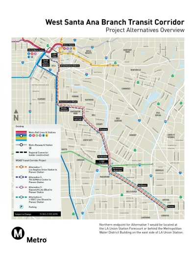
The Los Angeles County Metropolitan Transportation Authority (Metro) has approved a plan to build a light rail route currently called the West Santa Ana Branch Project.
Rachel Uranga reports for the Los Angeles Times:
Transportation officials gave the green light this week to a 19.3-mile light rail line that would serve largely working-class Latino communities in southeast Los Angeles County, and agreed to look for ways to speed up the project slated for completion in 2043.
The West Santa Ana Branch (WSAB) Transit Corridor, as the light rail route is currently called, would connect the city of Artesia to Union Station in Downtown Los Angeles, passing through the cities of Cerritos, Bellflower, Paramount, Downey, South Gate, Cudahy, Bell, Huntington Park, and Vernon, explains Uranga.
The current price tag for the project is estimated at $8.5 billion. "The rail line was part of Los Angeles Mayor Eric Garcetti’s plan to build 28 transit projects by the 2028 Olympics," according to Uranga, but the price tag compelled the Metro board to plan the route's construction in two phases. The first phase will break ground next year with an expected completion date ten years later. The second phase is expected for completion by 2043.
The Los Angeles Times story was picked up in its entirety by Mass Transit magazine, in case you haven't paid to access the Los Angeles Times.
FULL STORY: Rail line in southeast L.A. County approved as leaders seek to speed up construction

$1.9 Billion in State Budget Surplus Requested for L.A. Transit Projects
L.A. transit officials hope the state budget surplus can be used to fund regional transit project, including one highly anticipated light rail project that broke ground on Friday, December 2.
Newly Opened Regional Connector Redefines Light Rail Transit in Los Angeles
Three rail lines have become two rail lines in Los Angeles, providing one-seat rides from four corners of Los Angeles County.
Rail Transit Plans Would Connect L.A.’s South Bay to the Regional Rail System
Two new transit extensions promise several new routes for South Bay residents to access the Los Angeles region’s transit system.

National Parks Layoffs Will Cause Communities to Lose Billions
Thousands of essential park workers were laid off this week, just before the busy spring break season.

Retro-silient?: America’s First “Eco-burb,” The Woodlands Turns 50
A master-planned community north of Houston offers lessons on green infrastructure and resilient design, but falls short of its founder’s lofty affordability and walkability goals.

Delivering for America Plan Will Downgrade Mail Service in at Least 49.5 Percent of Zip Codes
Republican and Democrat lawmakers criticize the plan for its disproportionate negative impact on rural communities.

Test News Post 1
This is a summary

Test News Headline 46
Test for the image on the front page.

Balancing Bombs and Butterflies: How the National Guard Protects a Rare Species
The National Guard at Fort Indiantown Gap uses GIS technology and land management strategies to balance military training with conservation efforts, ensuring the survival of the rare eastern regal fritillary butterfly.
Urban Design for Planners 1: Software Tools
This six-course series explores essential urban design concepts using open source software and equips planners with the tools they need to participate fully in the urban design process.
Planning for Universal Design
Learn the tools for implementing Universal Design in planning regulations.
EMC Planning Group, Inc.
Planetizen
Planetizen
Mpact (formerly Rail~Volution)
Great Falls Development Authority, Inc.
HUDs Office of Policy Development and Research
NYU Wagner Graduate School of Public Service