


The pandemic-era ‘slow streets’ experiment has met with mixed reviews from residents, prompting the city to consider the removal or adjustment of many segments.

Of the nearly 30 ‘slow streets’ installed in San Francisco during the pandemic and “designed to limit through traffic on some residential streets to create a common, shared space for those also traveling on foot and by bicycle,” Max Darrow reports that “There are four slow street corridors that the SFMTA board authorized to stay in place beyond the state of emergency: Golden Gate Ave., Lake St., Sanchez St., and Shotwell St.”
Locals are divided on their utility. One resident, Vince Meyer, “Meyer thinks the slow street corridors will make the streets safer, will benefit the environment, and will be good for neighborhoods.” Another, Elisa Smith, says “A lot of these are just causing more problems than they are a source of enjoyment for people.” According to Smith, “There should be probably, an assessment done, of which ones are highly, highly used, and which ones are not.”
Darrow notes that “The SFMTA has removed several slow streets that were put up during the pandemic, such as Duncan, Excelsior, and Mariposa, due to low use and conflicts with other planning efforts, according to a spokesperson.”
FULL STORY: Quentions linger over future of San Francisco neighborhood 'Slow Streets'


San Francisco Nixes Slow Street
Lake Street’s designation as a ‘slow street’ is overwhelmingly popular with residents. Why does the city plan to dismantle it?
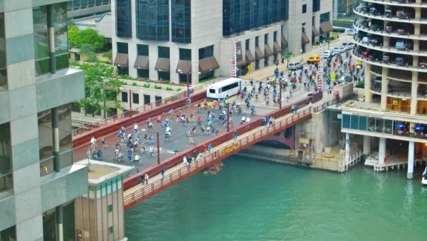
Chicago Dismantles Leland 'Slow Street' Three Months Early
Citing neighborhood concerns, the city is ending the Slow Street program on Leland Street as more parks and beaches reopen, but advocates want to see more permanent traffic calming measures.
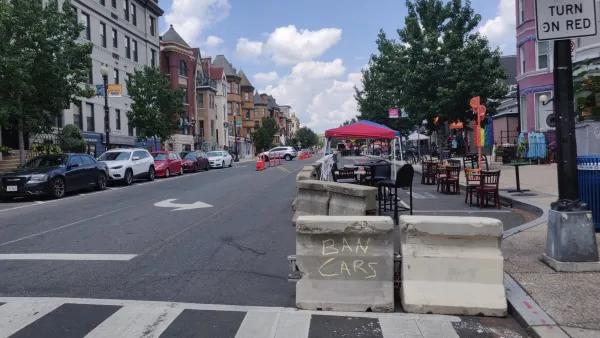
The Slow Streets Reckoning
Slow streets programs provided a quick short-term solution and paved the way for some permanent street closures and realignments. Now, these programs are getting a second look as community groups react to the changes.

National Parks Layoffs Will Cause Communities to Lose Billions
Thousands of essential park workers were laid off this week, just before the busy spring break season.

Retro-silient?: America’s First “Eco-burb,” The Woodlands Turns 50
A master-planned community north of Houston offers lessons on green infrastructure and resilient design, but falls short of its founder’s lofty affordability and walkability goals.

Delivering for America Plan Will Downgrade Mail Service in at Least 49.5 Percent of Zip Codes
Republican and Democrat lawmakers criticize the plan for its disproportionate negative impact on rural communities.

Test News Post 1
This is a summary

Test News Headline 46
Test for the image on the front page.

Balancing Bombs and Butterflies: How the National Guard Protects a Rare Species
The National Guard at Fort Indiantown Gap uses GIS technology and land management strategies to balance military training with conservation efforts, ensuring the survival of the rare eastern regal fritillary butterfly.
Urban Design for Planners 1: Software Tools
This six-course series explores essential urban design concepts using open source software and equips planners with the tools they need to participate fully in the urban design process.
Planning for Universal Design
Learn the tools for implementing Universal Design in planning regulations.
EMC Planning Group, Inc.
Planetizen
Planetizen
Mpact (formerly Rail~Volution)
Great Falls Development Authority, Inc.
HUDs Office of Policy Development and Research
NYU Wagner Graduate School of Public Service