


A nationwide ‘digital zoning atlas’ shows how different zoning districts overlap with and affect transportation, infrastructure, and housing affordability.
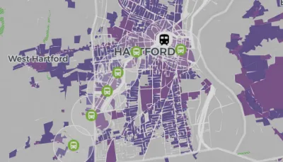
Inspired by a Connecticut project led by Cornell professor Sara Bronin, a group of academics, advocates, and policymakers are creating a nationwide ‘zoning atlas’ that will visualize local zoning codes and highlight how zoning rules impact the housing market. As Carl Smith reports in Governing, “Connecticut has the only statewide atlas that has been completed to date, but projects are already underway in California, Hawaii, Massachusetts, Montana, New Hampshire, New York and Ohio.”
The Connecticut project led to concrete policy changes, according to DesegregateCT director Peter Harrison. “You click and change from single-family housing allowed as-of-right to multifamily as-of-right, and the map goes blank — the story we’re trying to tell becomes real at a scale and speed that we could not do without it.”
The national effort is bringing together researchers from other states to map similar data. “This will help researchers who want to understand zoning’s impact on housing, education, environmental quality, climate change, transportation patterns, the economy and even government finances.”
Bronin and her collaborators hope that the atlas will provide a data-driven tool to help policymakers make informed decisions. “Our hope is that we’re laying the groundwork for many different people to use this information to guide decisions and also to engage people in the process of planning.”
FULL STORY: Digital Atlas Reveals Zoning’s Impact on Affordable Housing


NYC’s Proposed Zoning Reforms Lag Behind Other Cities
Cities like Austin and Minneapolis are making major changes to their zoning codes to encourage housing construction, but New York’s proposed reforms are far less ambitious.

Analysis: Localized Upzoning Less Effective
Changing zoning rules for a small number of parcels can increase land values and housing costs without boosting the housing supply.

NYC Likely to Legalize ADUs as Part of ‘City of Yes’ Reforms
Homeowners in some neighborhoods could soon be able to build accessory dwelling units in their backyards, garages, or basements.

National Parks Layoffs Will Cause Communities to Lose Billions
Thousands of essential park workers were laid off this week, just before the busy spring break season.

Retro-silient?: America’s First “Eco-burb,” The Woodlands Turns 50
A master-planned community north of Houston offers lessons on green infrastructure and resilient design, but falls short of its founder’s lofty affordability and walkability goals.

Delivering for America Plan Will Downgrade Mail Service in at Least 49.5 Percent of Zip Codes
Republican and Democrat lawmakers criticize the plan for its disproportionate negative impact on rural communities.

Test News Post 1
This is a summary

Test News Headline 46
Test for the image on the front page.

Balancing Bombs and Butterflies: How the National Guard Protects a Rare Species
The National Guard at Fort Indiantown Gap uses GIS technology and land management strategies to balance military training with conservation efforts, ensuring the survival of the rare eastern regal fritillary butterfly.
Urban Design for Planners 1: Software Tools
This six-course series explores essential urban design concepts using open source software and equips planners with the tools they need to participate fully in the urban design process.
Planning for Universal Design
Learn the tools for implementing Universal Design in planning regulations.
EMC Planning Group, Inc.
Planetizen
Planetizen
Mpact (formerly Rail~Volution)
Great Falls Development Authority, Inc.
HUDs Office of Policy Development and Research
NYU Wagner Graduate School of Public Service