


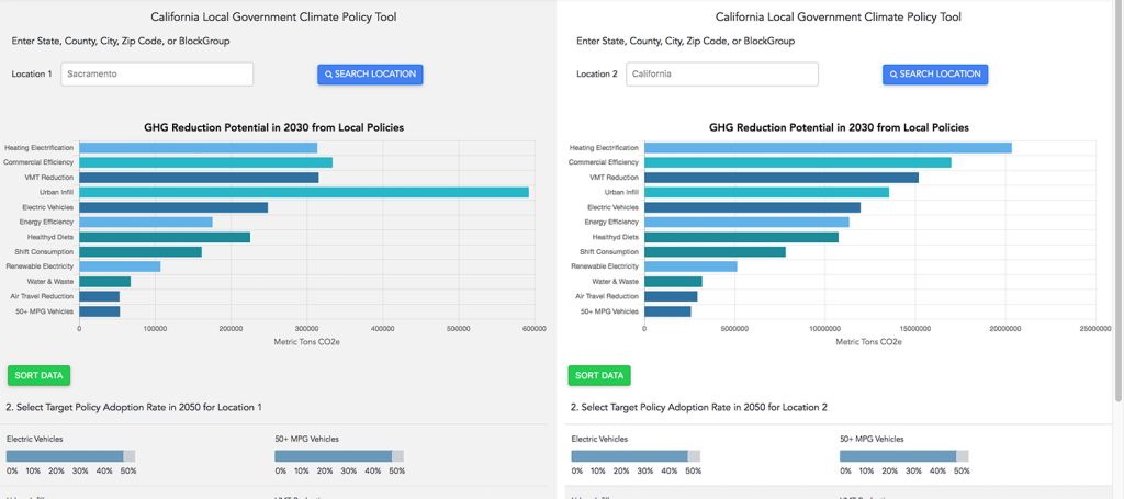
The CoolClimate Network's Interactive Policy Tools calculate and compare the GHG reductions provided by various emission reduction policies. These tools can help households, businesses and communities identify the best emission reduction strategies.
The climate crisis is pressing and solutions are urgently needed. The University of California, Berkeley's CoolClimate Network provides smart decision-making tools and programs to accelerate the transition to a clean energy economy. It is developing cutting-edge carbon footprint benchmarking research and combining this with ongoing lessons from behavioral sciences to design tailored climate solutions for specific users and populations.
CoolClimate tools can quickly identify the unique opportunities each individual, business, organization or community holds to reduce greenhouse gas emisions. These tools are incorporated into programs to activate, educate, motivate and empower individuals and organizations to make low-carbon choices.
These include:
Household Calculator. This calculates the emissions of specific households, taking into account their specific location, housing, transportation and consumption patterns, and ways that these can be reduced.
Business Calculator. This calculates the emissions of specific businesses, taking into account their specific location, housing, transportation and consumption patterns, and ways that these can be reduced.
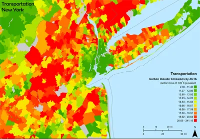
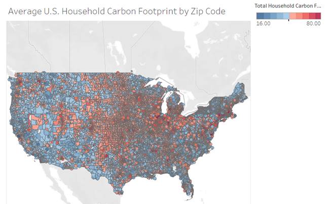
CoolClimate Maps. These custom heatmaps show household carbon emission rates for specific locations.
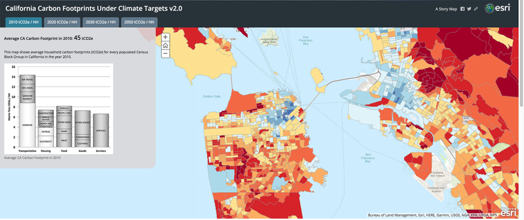
California Carbon Footprint Planning Tools and Scenarios
CoolClimate API allows software developers to create custom Carbon Footprint Calculators.
These tools are useful, interesting and fun to use, and produce beautiful maps. They are based on extensive and ongoing research concerning emission sources and the effectiveness of emission reduction strategies.


What Makes Affordable Housing Green?
There's no one way to determine what makes “green” housing. Here's a breakdown of the standards and considerations used by the affordable housing industry.

Oregon to End Sales of Gas-Powered Vehicles by 2035
There must be something about having a coast on the Pacific Ocean that makes states set policies to accelerate the end of the internal combustion engine.

COP27 Climate Negotiations Produce a Mixed Bag
Negotiators at this year’s COP27 climate change meetings can claim progress on some tricky issues, but stagnation reigns on the fundamental issue of emission reductions.
National Parks Layoffs Will Cause Communities to Lose Billions
Thousands of essential park workers were laid off this week, just before the busy spring break season.

Retro-silient?: America’s First “Eco-burb,” The Woodlands Turns 50
A master-planned community north of Houston offers lessons on green infrastructure and resilient design, but falls short of its founder’s lofty affordability and walkability goals.

Delivering for America Plan Will Downgrade Mail Service in at Least 49.5 Percent of Zip Codes
Republican and Democrat lawmakers criticize the plan for its disproportionate negative impact on rural communities.

Test News Post 1
This is a summary

Test News Headline 46
Test for the image on the front page.

Balancing Bombs and Butterflies: How the National Guard Protects a Rare Species
The National Guard at Fort Indiantown Gap uses GIS technology and land management strategies to balance military training with conservation efforts, ensuring the survival of the rare eastern regal fritillary butterfly.
Urban Design for Planners 1: Software Tools
This six-course series explores essential urban design concepts using open source software and equips planners with the tools they need to participate fully in the urban design process.
Planning for Universal Design
Learn the tools for implementing Universal Design in planning regulations.
EMC Planning Group, Inc.
Planetizen
Planetizen
Mpact (formerly Rail~Volution)
Great Falls Development Authority, Inc.
HUDs Office of Policy Development and Research
NYU Wagner Graduate School of Public Service