


After receiving complaints about parking loss and loading zone access, the city will consider revisions to a plan to make Connecticut Avenue safer for people on bikes, pedestrians, and transit users.
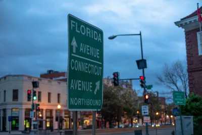
According to an article by Luz Lazo in The Washington Post, Washington, D.C. transportation officials are backing down on a plan to add bike lanes and safer pedestrian infrastructure to Connecticut Avenue. “D.C. transportation officials said they will work on design changes to address concerns about the loss of parking, effects on businesses, and access for people with disabilities and seniors along the busy commuter route in Northwest Washington.”
As Luz explains, “The planned transformation of Connecticut Avenue includes a northbound and southbound bike lane, new left- and right-turn lanes at some intersections, the relocation of bus stops to safer spots, pedestrian refuge islands, curb extensions and the prohibition of right turns on red lights.” While the revision is yet to be determined, “Officials said the city probably will stick with its original plan of a bike lane in each direction, with adjustments that include better loading access and parking alternatives.”
People who use Connecticut Avenue for biking say the street is “extremely dangerous and unsafe” for cyclists. One resident, Eztra Deutsch-Feldman, told the Post, “I know that for every rider brave enough to ride on [Connecticut Avenue] now, there are dozens more who want to ride on it but don't feel safe doing so.”
FULL STORY: In D.C., Connecticut Avenue bike lane plan to be revised

NACTO Releases Updated Urban Bikeway Guide
The third edition of the nationally recognized road design guide includes detailed design advice for roads that prioritize safety and accessibility for all users.

Southeast LA Road Safety Advocates Call for Improved Infrastructure
Streets in southeastern Los Angeles County have a severe lack of protected bike lanes and traffic safety measures, leading to high numbers of fatalities in a community where many residents depend on walking and biking for daily needs.

Philly Road Safety Advocates Call for Action From the City
Mayor Parker’s administration is proposing massive cuts to the city’s Vision Zero program while pedestrian and cyclist deaths remain high.

National Parks Layoffs Will Cause Communities to Lose Billions
Thousands of essential park workers were laid off this week, just before the busy spring break season.

Retro-silient?: America’s First “Eco-burb,” The Woodlands Turns 50
A master-planned community north of Houston offers lessons on green infrastructure and resilient design, but falls short of its founder’s lofty affordability and walkability goals.

Delivering for America Plan Will Downgrade Mail Service in at Least 49.5 Percent of Zip Codes
Republican and Democrat lawmakers criticize the plan for its disproportionate negative impact on rural communities.

Test News Post 1
This is a summary

Test News Headline 46
Test for the image on the front page.

Balancing Bombs and Butterflies: How the National Guard Protects a Rare Species
The National Guard at Fort Indiantown Gap uses GIS technology and land management strategies to balance military training with conservation efforts, ensuring the survival of the rare eastern regal fritillary butterfly.
Urban Design for Planners 1: Software Tools
This six-course series explores essential urban design concepts using open source software and equips planners with the tools they need to participate fully in the urban design process.
Planning for Universal Design
Learn the tools for implementing Universal Design in planning regulations.
EMC Planning Group, Inc.
Planetizen
Planetizen
Mpact (formerly Rail~Volution)
Great Falls Development Authority, Inc.
HUDs Office of Policy Development and Research
NYU Wagner Graduate School of Public Service