


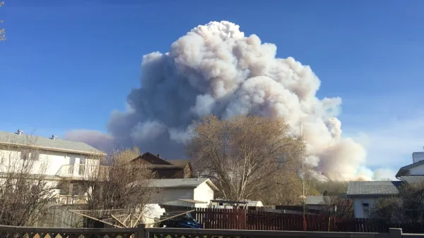
Sprawl in and around Austin is contributing to growing wildfire risks, and local officials worry about a lack of public awareness of the issue.
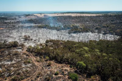
Fire risk is making its way from California to Texas along with tech companies and workers looking for more affordable housing, writes Patric Sisson in Bloomberg CityLab. As developers build more communities in the Austin suburbs to accommodate the growing population, neighborhood sprawl is increasingly encroaching on local forests.
“In general, the wildfire peril in Texas can’t compare to that in California, which is among the highest in the world, said Sam Carter, founding principal of Resilient Cities Catalyst.” But Austin city council member Alison Alter says “The fire risk in Austin is pretty serious, and I don’t think there’s a level of awareness that there is in California.” According to the article, over one third of Austin is at ‘high risk’ of fire.
Austin has experienced its own deadly fires in the past: “In 2011, nearly 1,700 buildings were destroyed when a wildfire tindered by downed power lines raced through drought-parched subdivisions in Bastrop County, southeast of Austin. More than 30,000 acres burned and two people were killed.” Conditions can be made worse by other natural disasters such as ice storms and deep freezes like the one that damaged infrastructure and felled trees and power lines across Texas in 2021.
“Creating a more fire-resilient central Texas would require a holistic approach and a lot of coordination between property owners: Unlike California, with its massive stock of state and national forests preserves and parks, 90% of Texas land is privately owned.” And while there is little optimism that builders will stop building, some cities are developing fire protection plans and coordinating fire response policies to prepare for future blazes.
FULL STORY: One More Thing Moving From California to Texas: Wildfire Risk

What Goes Together? Sprawl and Destructive Wildfires
Wildfires tend to start at the Wildland-Urban Interface: those border zones between cities and the open land surrounding them. Keeping the lid on sprawl, it can be argued, would tame the inferno.
Thank Climate Change and Sprawl for Worsening Wildfires
Along with climate conditions, urban sprawl is intensifying wildfires and increasing the damage they do.
The Incredible, Rising Cost of Forest Fires
The kicker in a recent article about the current realities of forest fires—and the cost of fighting them—in the United States: The federal government spends 624 percent more on fires than it did 20 years ago.

National Parks Layoffs Will Cause Communities to Lose Billions
Thousands of essential park workers were laid off this week, just before the busy spring break season.

Retro-silient?: America’s First “Eco-burb,” The Woodlands Turns 50
A master-planned community north of Houston offers lessons on green infrastructure and resilient design, but falls short of its founder’s lofty affordability and walkability goals.

Delivering for America Plan Will Downgrade Mail Service in at Least 49.5 Percent of Zip Codes
Republican and Democrat lawmakers criticize the plan for its disproportionate negative impact on rural communities.

Test News Post 1
This is a summary

Test News Headline 46
Test for the image on the front page.

Balancing Bombs and Butterflies: How the National Guard Protects a Rare Species
The National Guard at Fort Indiantown Gap uses GIS technology and land management strategies to balance military training with conservation efforts, ensuring the survival of the rare eastern regal fritillary butterfly.
Urban Design for Planners 1: Software Tools
This six-course series explores essential urban design concepts using open source software and equips planners with the tools they need to participate fully in the urban design process.
Planning for Universal Design
Learn the tools for implementing Universal Design in planning regulations.
EMC Planning Group, Inc.
Planetizen
Planetizen
Mpact (formerly Rail~Volution)
Great Falls Development Authority, Inc.
HUDs Office of Policy Development and Research
NYU Wagner Graduate School of Public Service