


The southeast Texas city is responding to community demands for safer, more accessible, and more diverse transportation choices.

Sugar Land, Texas,is adopting a new Mobility Master Plan aimed at aligning the goals and proposals in prior mobility, roadway, and bike and pedestrian plans and improving mobility for all types of road users in the sprawling, heavily car-oriented city southwest of Houston.
An article in the Fort Bend Independent quotes the master plan, which states:
For decades Sugar Land has successfully invested in mobility, primarily by building new streets and trails and increasing vehicular capacity.
To complement these investments, the community has asked the City to expand safe, healthy, and active transportation choices for all users, and continue to deploy mobility technology and update design treatments to optimize the space on existing streets.
The plan highlights the interconnectedness of transportation and land use policies, noting that “City staff should integrate public health considerations into all facets of transportation decision-making. This includes expanding greenspace for healthy activities, improving air quality, and ensuring that everyone can access their day-to-day destinations without a car.”
According to the plan, “the City must strategically re-imagine existing street corridors, build on innovative Intelligent Transportation System (ITS) investments, and adapt existing programs and policies to meet the evolving needs of the community.”
The plan establishes six ‘mobility metrics’ and a framework for tracking progress. “This plan identifies focus corridors for investment in a connected Transformative Mobility Network (TMN). Alongside this network, targeted Strategies & Action Items detail the projects, programs, and policies for the City to pursue over the next decade.”
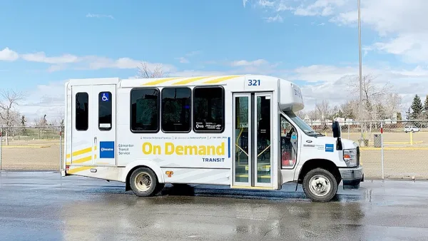
The plan adds, “This Strategy supports further investment in the existing demand response and park & ride services within Fort Bend County while also exploring other options, including microtransit, that support connectivity and access for Sugar Land residents, businesses, and commuters.” As part of the city’s goal to provide more transportation options, in May, the city applied for a grant from the Houston-Galveston Area Council (H-GAC) to establish an on-demand microtransit pilot program.
FULL STORY: Sugar Land Reimagines The City’s Future With A New Mobility Master Plan

Is Microtransit a Threat to ‘Real Transit’?
A new report warns that microtransit is nothing more than a taxpayer funded Uber with potentially dangerous consequences for existing traditional transit services.

Research: Sprawl Linked to Poverty
Low-income families living in high-sprawl neighborhoods are limited in their access to education, jobs, and other amenities, often trapping them in a cycle of poverty.
A Brief History of Kansas City’s Microtransit
The city’s costly experiment with on-demand transit is yielding to more strategic investment.

National Parks Layoffs Will Cause Communities to Lose Billions
Thousands of essential park workers were laid off this week, just before the busy spring break season.

Retro-silient?: America’s First “Eco-burb,” The Woodlands Turns 50
A master-planned community north of Houston offers lessons on green infrastructure and resilient design, but falls short of its founder’s lofty affordability and walkability goals.

Delivering for America Plan Will Downgrade Mail Service in at Least 49.5 Percent of Zip Codes
Republican and Democrat lawmakers criticize the plan for its disproportionate negative impact on rural communities.

Test News Post 1
This is a summary

Test News Headline 46
Test for the image on the front page.

Balancing Bombs and Butterflies: How the National Guard Protects a Rare Species
The National Guard at Fort Indiantown Gap uses GIS technology and land management strategies to balance military training with conservation efforts, ensuring the survival of the rare eastern regal fritillary butterfly.
Urban Design for Planners 1: Software Tools
This six-course series explores essential urban design concepts using open source software and equips planners with the tools they need to participate fully in the urban design process.
Planning for Universal Design
Learn the tools for implementing Universal Design in planning regulations.
EMC Planning Group, Inc.
Planetizen
Planetizen
Mpact (formerly Rail~Volution)
Great Falls Development Authority, Inc.
HUDs Office of Policy Development and Research
NYU Wagner Graduate School of Public Service