


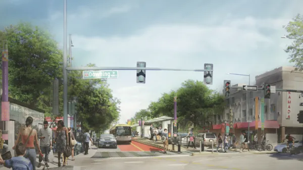
Denver councilmembers are proposing an overhaul of land use regulations along a long stretch of East Colfax Avenue—the route of a planned Bus Rapid Transit line expected to open in 2026.
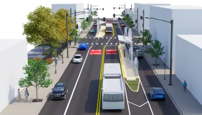
Denver is working on plans for an ambitious new Bus Rapid Transit (BRT) project on East Colfax Avenue, a major commercial corridor to the east of Downtown Denver.
“Planners expect [the BRT route] to open in 2026, and officials say it will speed up public transportation along Colfax, transform parts of the street and promote economic growth,” reports Rebecca Tauber in an article for Denverite.
In addition to street configuration and service design questions, Colfax planners are also hoping to include land use planning changes to optimize the benefit of the new system, according to Tauber.
City councilmembers Chris Hinds and Amanda Sawyer recently proposed zoning changes that rezone a long stretch of Colfax Avenue (between Broadway and Yosemite Street) to prioritize walkability, according to the article.
The proposed zoning changes “would include restrictions on things like drive-thrus, storage facilities and carwashes in order to promote businesses facing future BRT stops that cater to pedestrians,” according to Tauber. “The zoning also includes a setback – building a set number of feet back for better sidewalk access – and other design guidelines at the street level. The plan does not include every parcel but focuses on wide ones near BRT stops. It also only applies to new developments. It would not change parking requirements or allow for building uses currently prohibited along Colfax.”
According to city website for the East Colfax Avenue Bus Rapid Transit project, planning for the project is in the final design phase, working to refine station designs, streetscaping, logo design, and conducting curbside safety analysis, among other tasks. The Denver Department of Transportation and Infrastructure is leading the project.

Lack of Funding Hits the Brakes for Planned Bus Rapid Transit Route in Denver
Funding for a $200 million bus rapid transit route on East Colfax Avenue in Denver is well behind schedule.

California Makes Planning History, Resets the Housing Status Quo
The California Legislature this week approved a historic package of bills, including a bill that allows affordable housing on commercially zoned properties and another that removes parking requirements near transit.
Denver Reduces Parking Requirements for Affordable Housing
The zoning change will significantly reduce the cost of building affordable housing developments.

National Parks Layoffs Will Cause Communities to Lose Billions
Thousands of essential park workers were laid off this week, just before the busy spring break season.

Retro-silient?: America’s First “Eco-burb,” The Woodlands Turns 50
A master-planned community north of Houston offers lessons on green infrastructure and resilient design, but falls short of its founder’s lofty affordability and walkability goals.

Delivering for America Plan Will Downgrade Mail Service in at Least 49.5 Percent of Zip Codes
Republican and Democrat lawmakers criticize the plan for its disproportionate negative impact on rural communities.

Test News Post 1
This is a summary

Test News Headline 46
Test for the image on the front page.

Balancing Bombs and Butterflies: How the National Guard Protects a Rare Species
The National Guard at Fort Indiantown Gap uses GIS technology and land management strategies to balance military training with conservation efforts, ensuring the survival of the rare eastern regal fritillary butterfly.
Urban Design for Planners 1: Software Tools
This six-course series explores essential urban design concepts using open source software and equips planners with the tools they need to participate fully in the urban design process.
Planning for Universal Design
Learn the tools for implementing Universal Design in planning regulations.
EMC Planning Group, Inc.
Planetizen
Planetizen
Mpact (formerly Rail~Volution)
Great Falls Development Authority, Inc.
HUDs Office of Policy Development and Research
NYU Wagner Graduate School of Public Service