


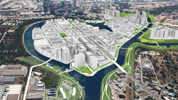
Originally planned as a primarily residential development, the riverfront development could shift to a focus on entertainment, commerce, and outdoor recreation.
A massive riverfront district in Fort Worth, Texas could be up for a reimagining after a new report that calls on the city to reconsider the plan for the area. Jenny Rudolph, Harrison Mantas, and Abby Church outline the report’s findings in the Fort Worth Star-Telegram.
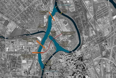
As the article explains, “The $1.1 billion public investment to mitigate Trinity River flooding by building new channels will open up more than 5 miles of shoreline and 200 acres for development just north of downtown. As originally conceived, Panther Island’s development would be focused on dense residential buildings with some commercial.”
Now, the report from a consultant firm calls for more mixed-use development in Panther Island and “stresses the need for a unified development strategy for the more than 500 acres of public and privately owned land, as well as the need to avoid displacing surrounding communities such as the historic North Side.”
“Planners are moving away from the residential-focused original plans and instead envision a district with a vibrant entertainment hub, outdoor recreation and the potential to attract companies and talent to the city, HR&A’s report said.” The report adds that the district should be pedestrian-friendly, accessible, and have a “recognizable and distinct identity while also complementing the adjacent downtown and connecting seamlessly with surrounding neighborhoods.”
According to the article, “Although conceived years ago, the project got an official greenlight in January 2022 when the U.S. Army Corps of Engineers received $403 million from the federal government to create the bypass channel connecting two sections of the Trinity River.”
FULL STORY: The vision for Fort Worth’s Panther Island is changing. Here’s what a new report says.

Budget Worries Threaten Vision for Fort Worth Riverfront District and Flood Control Project
An ambitious stormwater infrastructure project in Fort Worth would also include a mega-project development of a new riverfront district. Funding has become a problem, well into work on the project.
First Look at Alexandria’s Ambitious Waterfront Redesign
Following a Waterfront Small Area Plan adopted in January 2012, Alexandria, Virginia got its first look at proposed designs for the redevelopment of its Old Town waterfront this week.
Huge Redevelopment Project Coming to Sacramento
12,000 new homes could be coming to Sacramento over the next two decades -- part of a $5.3 billion redevelopment focused on the city's historic railyards.

National Parks Layoffs Will Cause Communities to Lose Billions
Thousands of essential park workers were laid off this week, just before the busy spring break season.

Retro-silient?: America’s First “Eco-burb,” The Woodlands Turns 50
A master-planned community north of Houston offers lessons on green infrastructure and resilient design, but falls short of its founder’s lofty affordability and walkability goals.

Delivering for America Plan Will Downgrade Mail Service in at Least 49.5 Percent of Zip Codes
Republican and Democrat lawmakers criticize the plan for its disproportionate negative impact on rural communities.

Test News Post 1
This is a summary

Test News Headline 46
Test for the image on the front page.

Balancing Bombs and Butterflies: How the National Guard Protects a Rare Species
The National Guard at Fort Indiantown Gap uses GIS technology and land management strategies to balance military training with conservation efforts, ensuring the survival of the rare eastern regal fritillary butterfly.
Urban Design for Planners 1: Software Tools
This six-course series explores essential urban design concepts using open source software and equips planners with the tools they need to participate fully in the urban design process.
Planning for Universal Design
Learn the tools for implementing Universal Design in planning regulations.
EMC Planning Group, Inc.
Planetizen
Planetizen
Mpact (formerly Rail~Volution)
Great Falls Development Authority, Inc.
HUDs Office of Policy Development and Research
NYU Wagner Graduate School of Public Service