


The Los Angeles County Department of Parks and Recreation uses GIS technology to identify priority areas for land conservation and restoration as part of its 30x30 plan to fight climate change and protect biodiversity.

In December 2022, the Los Angeles County Board of Supervisors adopted the Parks Needs Assessment Plus (PNA+), which complements and offers information not previously included in the 2016 Los Angeles Countywide Parks and Recreation Needs Assessment (PNA). Specifically, PNA+ contains data and analyses in support of expanding land conservation and restoration, improving transit to parks, and other strategies to meet regional and rural recreation needs, especially in the county's most vulnerable communities.
In this article, Sunny Fleming and Sophia Garcia discuss how the L.A. County Department of Parks and Recreation (DPR) used GIS technology as part of the PNA+ to: 1) identify priority areas for conservation and restoration; 2) assess the needs of rural residents who live near open land but have few recreational amenities; and 3) support a strategy of remediating degraded lands in underserved neighborhoods.
The PNA+ is L.A. County's 30x30 strategy which is equity-focused and aligns with state and federal goals to conserve 30 percent of lands and coastal waters by the year 2030 to fight climate change and protect biodiversity. PNA+ addresses both environmental conservation and restoration. It identifies priority areas for environmental conservation which are areas that offer the most environmental benefits as measured by species diversity, significant habitat, habitat connectivity, proximity to a waterbody, and habitat type.
The study also calls out priority areas for environmental restoration. These are areas that have the most environmental burdens with respect to groundwater threat, hazardous waste, poor air and water quality, and pollution burden. Examples include oil fields, brownfields, landfills, and other degraded lands which may be converted to parks and open space in the future. The restoration of degraded lands is of great importance and a matter of environmental justice in L.A. County where numerous underserved communities are plagued with environmental burdens.
FULL STORY: Los Angeles County Maps Equitable Access to Nature, Remediates Degraded Lands


Los Angeles County's 30x30 Strategy Earns National Recognition
L.A. County's Parks Needs Assessment Plus (PNA+) received a 2023 achievement award from the National Association of Counties (NACo).

Bringing Communities Together: Lunar New Year Festivities Across LA County
To celebrate the Lunar New Year, LA County Parks is hosting free community festivals at 61 parks, featuring cultural performances, food tastings, crafts, and interactive activities that honor the Year of the Snake and promote unity and tradition.
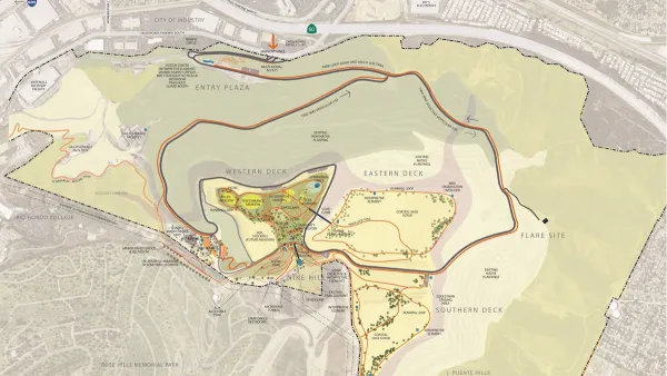
Trash to Treasure: New Park Set to Redefine Open Space in the San Gabriel Valley
Puente Hills Landfill Park, opening in 2027, will transform a former landfill into a regional park with trails, scenic vistas, and various amenities, addressing environmental justice and providing much-needed green space for the San Gabriel Valley.

National Parks Layoffs Will Cause Communities to Lose Billions
Thousands of essential park workers were laid off this week, just before the busy spring break season.

Retro-silient?: America’s First “Eco-burb,” The Woodlands Turns 50
A master-planned community north of Houston offers lessons on green infrastructure and resilient design, but falls short of its founder’s lofty affordability and walkability goals.

Delivering for America Plan Will Downgrade Mail Service in at Least 49.5 Percent of Zip Codes
Republican and Democrat lawmakers criticize the plan for its disproportionate negative impact on rural communities.

Test News Post 1
This is a summary

Test News Headline 46
Test for the image on the front page.

Balancing Bombs and Butterflies: How the National Guard Protects a Rare Species
The National Guard at Fort Indiantown Gap uses GIS technology and land management strategies to balance military training with conservation efforts, ensuring the survival of the rare eastern regal fritillary butterfly.
Urban Design for Planners 1: Software Tools
This six-course series explores essential urban design concepts using open source software and equips planners with the tools they need to participate fully in the urban design process.
Planning for Universal Design
Learn the tools for implementing Universal Design in planning regulations.
EMC Planning Group, Inc.
Planetizen
Planetizen
Mpact (formerly Rail~Volution)
Great Falls Development Authority, Inc.
HUDs Office of Policy Development and Research
NYU Wagner Graduate School of Public Service