


Not all trails are accessible to those with limited mobility. This article highlights eight trails and nature walks in Southern California that can be enjoyed by just about anyone.

Trail can provide people of every age, ability, and socioeconomic background safe and inexpensive settings for outdoor physical activity, recreation, and transportation. Within Los Angeles County, there are over 3,300 miles of regional trails managed by numerous agencies, according to the Parks Needs Assessment Plus (PNA+) completed by the L.A. County Department of Parks and Recreation (DPR) in 2022. However, not all trails are accessible to people with limited mobility, including those who use wheelchairs or other equipment to help them get around, individuals who are older or have physical disabilities, and children who are not yet able to traverse rocky or steep inclines.
In this article, Laura Newberry highlights eight hikes and nature walks (two of which are maintained by DPR) within an hour’s drive of L.A. that can be enjoyed by just about everyone, including those at the following locations:
- Mount Wilson Observatory (Angeles National Forest)
- El Dorado Nature Center (Long Beach)
- Bolsa Chica Ecological Reserve (Huntington Beach)
- Placerita Canyon Nature Center (Santa Clarita)
- West Fork National Scenic Bikeway (Angeles National Forest)
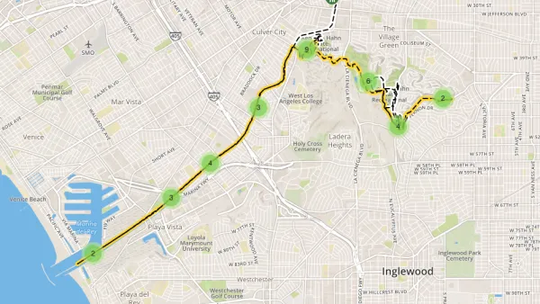
- Kenneth Hahn State Recreation Area (Westside)
- Point Vicente Interpretive Center and Lighthouse (Rancho Palos Verdes)
- The Gabrielano Trail (Altadena)
To learn more about each of them, please read the source article.
On a related note, DPR maintains trails website and a Trails LA County mobile app. The website and mobile app promote the use of trails and inform the public of the value and importance of stewardship, conservation, and habitat restoration of open space. The website is intended to be the go-to online resource for the public to find official trail information throughout the county, while the new mobile app provides an on-the-go experience. Both the website and app offer digital tools, including information on real-time alerts, maps, weather, trail length, elevation, difficulty level, rest stops, picnic locations, and more.
FULL STORY: These 8 L.A. trails are accessible to everyone, from wheelchair users to kids in strollers

13-Mile Park to Playa Trail Seizes the Moment in South Los Angeles
A new 13-mile regional trail opens in South Los Angeles, connecting various parks to the Pacific Ocean and providing additional opportunities for residents to enjoy outdoor recreation during a pandemic.
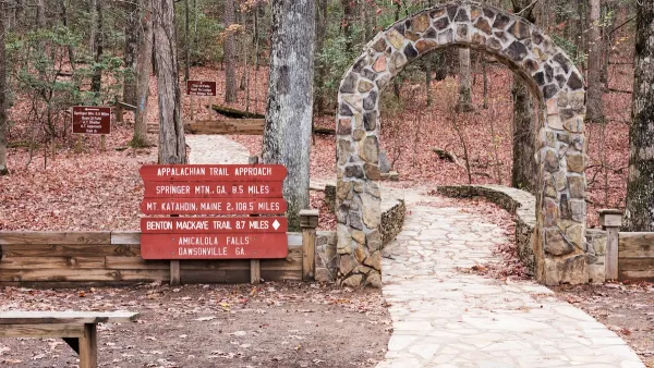
Hikers Take Solace: The Appalachian Trail Will Survive Hurricane Helene
Despite concerns and closures in the wake of Hurricane Helene, most of the trail appears to have suffered minor damage.

Creating a New Regional Park by Restoring Degraded Lands
Los Angeles County is transforming 142 acres of the Puente Hills Landfill into parkland, creating the first new regional park in the county in over 35 years. The recently released concept plan and renderings show what the park will look like.

National Parks Layoffs Will Cause Communities to Lose Billions
Thousands of essential park workers were laid off this week, just before the busy spring break season.

Retro-silient?: America’s First “Eco-burb,” The Woodlands Turns 50
A master-planned community north of Houston offers lessons on green infrastructure and resilient design, but falls short of its founder’s lofty affordability and walkability goals.

Delivering for America Plan Will Downgrade Mail Service in at Least 49.5 Percent of Zip Codes
Republican and Democrat lawmakers criticize the plan for its disproportionate negative impact on rural communities.

Test News Post 1
This is a summary

Test News Headline 46
Test for the image on the front page.

Balancing Bombs and Butterflies: How the National Guard Protects a Rare Species
The National Guard at Fort Indiantown Gap uses GIS technology and land management strategies to balance military training with conservation efforts, ensuring the survival of the rare eastern regal fritillary butterfly.
Urban Design for Planners 1: Software Tools
This six-course series explores essential urban design concepts using open source software and equips planners with the tools they need to participate fully in the urban design process.
Planning for Universal Design
Learn the tools for implementing Universal Design in planning regulations.
EMC Planning Group, Inc.
Planetizen
Planetizen
Mpact (formerly Rail~Volution)
Great Falls Development Authority, Inc.
HUDs Office of Policy Development and Research
NYU Wagner Graduate School of Public Service