


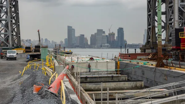
A tour of new infrastructure designed to protect the city’s East Side from catastrophic flooding.

In an article for Curbed, Christopher Bonanos tours the waterfront on Manhattan’s East Side with Rohit Aggarwala, commissioner of the city’s Department of Environmental Protection and chief climate officer to better understand the flood defense mechanisms the city is installing.
The area was hard-hit by Hurricane Sandy, when water reached three blocks inland, destroying cars and basements. Now, the city is elevating East River Park and building a series of dikes and gates along the coastline north of the park. Bonanos points out that while the barriers are built to withstand storm surges, “They won’t be able to do anything about the immensely heavy rainstorms we’re now getting, including Ophelia, the storm we just had in late September.”
Aggarwala acknowledges that “The gates may be good for a century, but that figure depends somewhat on how many storms we get.” And while the designs may get backlash, “we’re going to lose something — whether it’s views, or a shorter walk to the water, or simply the ability to pretend we’re not up against the sea — because the world of the 22nd century is not going to look like ours.”
FULL STORY: Walling Up the East Side to Save It

New York Flood Control Plan Takes Lessons From the Dutch
The Netherlands has a long history of flood mitigation. U.S. cities, threatened by coastal flooding and erosion, are taking note.

Net Zero Development Coming to New York City
The project, which relies largely on geothermal energy to minimize its carbon footprint, will bring affordable housing and boost storm resilience to an area devastated by Hurricane Sandy.

Saving Lower Manhattan
A debate over how to protect the East River waterfront from Sandy-level flooding and storm damage has delayed the project as community activists decry the city's last-minute change of plans.

National Parks Layoffs Will Cause Communities to Lose Billions
Thousands of essential park workers were laid off this week, just before the busy spring break season.

Retro-silient?: America’s First “Eco-burb,” The Woodlands Turns 50
A master-planned community north of Houston offers lessons on green infrastructure and resilient design, but falls short of its founder’s lofty affordability and walkability goals.

Delivering for America Plan Will Downgrade Mail Service in at Least 49.5 Percent of Zip Codes
Republican and Democrat lawmakers criticize the plan for its disproportionate negative impact on rural communities.

Test News Post 1
This is a summary

Test News Headline 46
Test for the image on the front page.

Balancing Bombs and Butterflies: How the National Guard Protects a Rare Species
The National Guard at Fort Indiantown Gap uses GIS technology and land management strategies to balance military training with conservation efforts, ensuring the survival of the rare eastern regal fritillary butterfly.
Urban Design for Planners 1: Software Tools
This six-course series explores essential urban design concepts using open source software and equips planners with the tools they need to participate fully in the urban design process.
Planning for Universal Design
Learn the tools for implementing Universal Design in planning regulations.
EMC Planning Group, Inc.
Planetizen
Planetizen
Mpact (formerly Rail~Volution)
Great Falls Development Authority, Inc.
HUDs Office of Policy Development and Research
NYU Wagner Graduate School of Public Service