


The White House is sending a top-level cabinet member who oversees the U.S. Forest Service to the San Gabriel Valley east of Los Angeles to hear public comments on the proposed expansion the San Gabriel Mountains National Monument.

The San Gabriel Mountains National Monument is a National Monument managed by the U.S. Forest Service, which encompasses parts of the Angeles National Forest and the San Bernardino National Forest in California. On October 10, 2014, President Barack Obama used his authority under the Antiquities Act to create the new monument, protecting 346,177 acres of public lands in the San Gabriel Mountains of the Transverse Ranges.
Twin bills from Rep. Judy Chu, (D-Pasadena) and Sen. Alex Padilla, (D-Calif.) introduced in May this year propose adding 109,167 acres of Angeles National Forest land to the 346,179-acre San Gabriel Mountains National Monument. The monument includes 342,177 acres of the Angeles National Forest and 4,002 acres of neighboring San Bernardino National Forest. The bills would also designate more than 30,000 acres of protected wilderness and add 45.5 miles to the National Wild and Scenic Rivers System.
In this article, Steve Scauzillo reports that Homer Wilkes, undersecretary of the U.S. Department of Agriculture for natural resources and environment, will be in the San Gabriel Valley to hear from the public on November 7, 2023 as to whether President Joe Biden should expand the San Gabriel Mountains National Monument. Biden nominated Wilkes as under secretary in 2021 and he was confirmed by the U.S. Senate on February 8, 2022. Wilkes has a history of working on conservation and restoration of public lands.
FULL STORY: Top Biden official will hear from public on expanding San Gabriel Mountains National Monument

Expansion of the San Gabriel Mountains National Monument Approved
President Biden just signed a proclamation to expand the San Gabriel Mountains National Monument by over 100,000 acres.
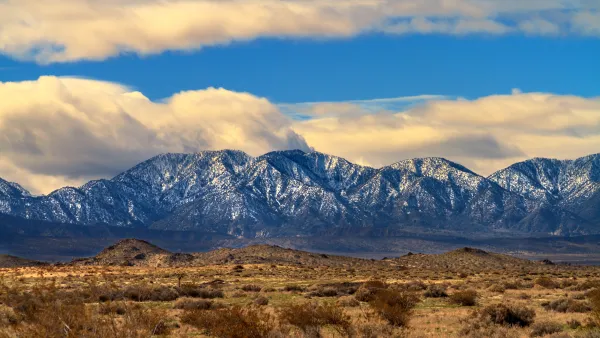
Growing Support for Expanding the San Gabriel Mountains National Monument
Members of Congress are proposing an expansion to the national monument by over 109,000 acres, increasing its size by nearly a third.

National Parks Layoffs Will Cause Communities to Lose Billions
Thousands of essential park workers were laid off this week, just before the busy spring break season.
National Parks Layoffs Will Cause Communities to Lose Billions
Thousands of essential park workers were laid off this week, just before the busy spring break season.

Retro-silient?: America’s First “Eco-burb,” The Woodlands Turns 50
A master-planned community north of Houston offers lessons on green infrastructure and resilient design, but falls short of its founder’s lofty affordability and walkability goals.

Delivering for America Plan Will Downgrade Mail Service in at Least 49.5 Percent of Zip Codes
Republican and Democrat lawmakers criticize the plan for its disproportionate negative impact on rural communities.

Test News Post 1
This is a summary

Test News Headline 46
Test for the image on the front page.

Balancing Bombs and Butterflies: How the National Guard Protects a Rare Species
The National Guard at Fort Indiantown Gap uses GIS technology and land management strategies to balance military training with conservation efforts, ensuring the survival of the rare eastern regal fritillary butterfly.
Urban Design for Planners 1: Software Tools
This six-course series explores essential urban design concepts using open source software and equips planners with the tools they need to participate fully in the urban design process.
Planning for Universal Design
Learn the tools for implementing Universal Design in planning regulations.
EMC Planning Group, Inc.
Planetizen
Planetizen
Mpact (formerly Rail~Volution)
Great Falls Development Authority, Inc.
HUDs Office of Policy Development and Research
NYU Wagner Graduate School of Public Service