


A new proposal reimagines the primarily industrial and office-oriented area to a ‘15-minute city.’
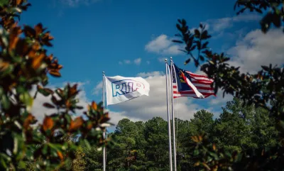
Local leaders in North Carolina’s Research Triangle Park (RTP) are proposing zoning changes that would make the area more mixed-use and boost density in the economically fertile but sprawling region, writes Mary Helen Moore in a story for The News & Observer.
According to Research Triangle Foundation CEO and president Scott Levitan, “the development model for RTP has not really kept up with the way innovation communities around our country and around the world have evolved,” with 20 percent of the area covered by surface parking lots.
Now, the foundation is developing a vision modeled on the ’15-minute city’ concept that would bring a wider variety of businesses and homes to the area and make it easier for residents, workers, and visitors to get around.
RTP straddles two counties, Durham and Wake, and is specially zoned for low-density campuses. “Levitan said they aim to ask both counties for a new overlay for the park by the end of 2024, giving private land owners considerable options for future development.” The proposed overlay would include three new ‘place types:’ enhanced corporate campus, residential neighborhoods with amenities like grocery stores, and mixed-use density nodes. Additionally, “Because landowners in RTP are governed by private covenants, the RTP Planning Board could require environmentally sustainable design or affordable housing, which the state of North Carolina preempts local governments from doing.”
Park leaders are also interested in mirroring Durham’s ‘social district,’ which allows people to walk around with alcoholic beverages in a designated commercial area.
FULL STORY: A 15-minute-city? Leaders propose rezoning all of RTP and adding a drinking district (North Carolina)


Will New York ‘City of Yes’ Proposal Make an Impact?
Some housing experts say the rezoning plan is not nearly ambitious enough to make a dent in the city’s housing crisis.

Edmonton to Revise Zoning Code
Proposed changes could help spur more housing development in the Canadian city and encourage density increases in residential neighborhoods.
Pittsburgh Moves Ahead With Zoning Changes for University-Adjacent Neighborhood
The implementation of a new master plan for the neighborhood of Oakland, home to the University of Pittsburgh, is moving forward despite controversy and a contentious community engagement process.

National Parks Layoffs Will Cause Communities to Lose Billions
Thousands of essential park workers were laid off this week, just before the busy spring break season.

Retro-silient?: America’s First “Eco-burb,” The Woodlands Turns 50
A master-planned community north of Houston offers lessons on green infrastructure and resilient design, but falls short of its founder’s lofty affordability and walkability goals.

Delivering for America Plan Will Downgrade Mail Service in at Least 49.5 Percent of Zip Codes
Republican and Democrat lawmakers criticize the plan for its disproportionate negative impact on rural communities.

Test News Post 1
This is a summary

Test News Headline 46
Test for the image on the front page.

Balancing Bombs and Butterflies: How the National Guard Protects a Rare Species
The National Guard at Fort Indiantown Gap uses GIS technology and land management strategies to balance military training with conservation efforts, ensuring the survival of the rare eastern regal fritillary butterfly.
Urban Design for Planners 1: Software Tools
This six-course series explores essential urban design concepts using open source software and equips planners with the tools they need to participate fully in the urban design process.
Planning for Universal Design
Learn the tools for implementing Universal Design in planning regulations.
EMC Planning Group, Inc.
Planetizen
Planetizen
Mpact (formerly Rail~Volution)
Great Falls Development Authority, Inc.
HUDs Office of Policy Development and Research
NYU Wagner Graduate School of Public Service