


The interactive map details zoning rules along with local services like sanitation, transportation, and more.
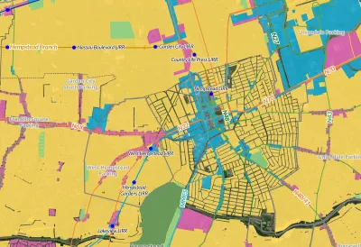
A new interactive ‘zoning atlas’ offers Long Island residents a way to understand the complex web of land use, municipal services, transportation, and zoning districts on the island. As Desiree D'Iorio explains in a piece for WSHU, “It can be filtered to show details like public transportation routes, downtown areas, current land use and special districts for services like sewers, schools, ambulances and sanitation.”
Gwen O'Shea, president of Community Development Long Island, said the tool can help governments and builders understand what type of housing is permitted where and how those regulations intersect with services like transit. “It can help developers see what building opportunities are available, and help officials and housing advocates understand how housing policies impact homeowners and communities.”
FULL STORY: New tool hopes to change how Long Island understands its complex zoning


Barriers to Integration Come Down Slowly in Wealthy, White Suburban Enclaves
Beware of possible code words like "character" and "flavor" when it comes to community resistance to multifamily housing or increased density. Case in point, Garden City, Long Island.

Commentary: We Need a Return to the Adaptability of Traditional Urban Form
How the rigidity of modern suburban development fails to prepare cities for the future.

Rethinking Suburban Development: New Trends in Creating Livable Communities
Discover new trends in suburban development focused on creating more livable, sustainable communities for future growth.

Analysis: Cybertruck Fatality Rate Far Exceeds That of Ford Pinto
The Tesla Cybertruck was recalled seven times last year.

National Parks Layoffs Will Cause Communities to Lose Billions
Thousands of essential park workers were laid off this week, just before the busy spring break season.

Retro-silient?: America’s First “Eco-burb,” The Woodlands Turns 50
A master-planned community north of Houston offers lessons on green infrastructure and resilient design, but falls short of its founder’s lofty affordability and walkability goals.

Test News Post 1
This is a summary

Analysis: Cybertruck Fatality Rate Far Exceeds That of Ford Pinto
The Tesla Cybertruck was recalled seven times last year.

Test News Headline 46
Test for the image on the front page.
Urban Design for Planners 1: Software Tools
This six-course series explores essential urban design concepts using open source software and equips planners with the tools they need to participate fully in the urban design process.
Planning for Universal Design
Learn the tools for implementing Universal Design in planning regulations.
EMC Planning Group, Inc.
Planetizen
Planetizen
Mpact (formerly Rail~Volution)
Great Falls Development Authority, Inc.
HUDs Office of Policy Development and Research
NYU Wagner Graduate School of Public Service