


With the ability to predict trends, engage citizens, enhance resource allocation, and guide decision-making, artificial intelligence has the potential to serve as planners’ very own multi-tool.
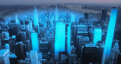
“The convergence of artificial intelligence (AI) and urban planning holds significant promise for creating more intelligent, efficient, and sustainable cities,” Camilla Ghisleni. In an article for Arch Daily, she outlines four applications of urban planning, spurred by “a surge in development of applications, softerware, and other technological systems” tailored to support city design.
1. Urban design and morphology
Ghisleni cites multiple projects and studies around the world that are using AI to analyze and create plans in a fraction of the time it would take human urban planners and with better results, including grid-based planning, rapid urban prototyping, and digital twin technology.
2. Resilience and climate adaptation
AI can also be used to enhance resilience against extreme weather events and climate change, Ghisleni reports, pointing to Google’s AI-powered tree-cover assessment tool and IBM’s AI tool that calculates the amount of carbon trees in specific areas can store, which can help when choosing species for carbon sequestration.
3. Infrastructure planning
Ghisleni highlights a software called MAIIA (Automated Mapping of Informal Settlements with Artificial Intelligence) that was created by Columbia’s National Planning Department and made available as part of a catalog of open-source tools for urban planning, with the goal of facilitating “automated detection and mapping of informal settlements in various locations, providing efficient and accessible solutions to housing challenges.”
4. Community engagement
Finally, Ghisleni covers applications including virtual reality (VR) or augmented reality (AR) to encourage a more participatory planning process, as well as real-time monitoring and analysis of user-generated data for things like traffic management and route safety alerts for women and pedestrians.
FULL STORY: Artificial Intelligence and Urban Planning: Technology as a Tool for City Design

Augmented Reality and Public Art: A New Era Begins Today
People in six global cities will have a chance to sample an ambitious new augmented reality program launched by Apple today.

Making a Place for Virtual Reality in Planning
As virtual reality technology becomes more accessible, it's time to start considering how immersive virtual experiences could help inform visioning process and design decision-making.

Fighting Forest Pests With AI: A Hemlock Success Story
Fairfax County utilized GeoAI and ArcGIS technology to efficiently map and protect its hemlock trees from the invasive woolly adelgid, ensuring targeted pest management and preservation of its evergreen canopy.

National Parks Layoffs Will Cause Communities to Lose Billions
Thousands of essential park workers were laid off this week, just before the busy spring break season.

Retro-silient?: America’s First “Eco-burb,” The Woodlands Turns 50
A master-planned community north of Houston offers lessons on green infrastructure and resilient design, but falls short of its founder’s lofty affordability and walkability goals.

Delivering for America Plan Will Downgrade Mail Service in at Least 49.5 Percent of Zip Codes
Republican and Democrat lawmakers criticize the plan for its disproportionate negative impact on rural communities.

Test News Post 1
This is a summary

Test News Headline 46
Test for the image on the front page.

Balancing Bombs and Butterflies: How the National Guard Protects a Rare Species
The National Guard at Fort Indiantown Gap uses GIS technology and land management strategies to balance military training with conservation efforts, ensuring the survival of the rare eastern regal fritillary butterfly.
Urban Design for Planners 1: Software Tools
This six-course series explores essential urban design concepts using open source software and equips planners with the tools they need to participate fully in the urban design process.
Planning for Universal Design
Learn the tools for implementing Universal Design in planning regulations.
EMC Planning Group, Inc.
Planetizen
Planetizen
Mpact (formerly Rail~Volution)
Great Falls Development Authority, Inc.
HUDs Office of Policy Development and Research
NYU Wagner Graduate School of Public Service