


The San Joaquin Valley has some of the worst air pollution and particulate matter emissions in the nation, but agricultural sources are loosely regulated.
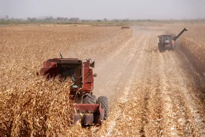
California’s most intensively farmed counties don’t pass the EPA’s newest standards for particulate matter, reports Virginia Gewin in Civil Eats. Some are not even close to reaching the prior target established in 2012. “Agriculture’s contribution to PM2.5 stems from burning, soil management, and gaseous emissions from both tractors and soil,” Gewin explains.
“The San Joaquin Valley is the largest agricultural producing area in the nation; it produced crops, livestock, and agricultural commodities worth $36.5 billion in 2022. The southern half of California’s 450-mile Central Valley is also home to some of the worst annual air pollution in the nation. Mountain ranges trap emissions from highway traffic, locomotives, municipal composting facilities, tractors, and burning.”
The article details steps the district is taking to reduce emissions and improve air quality in the regions, but critics say the regulations don’t go far enough in the agricultural sector. For example, agricultural tractors are not regulated by CARB, despite being a major source of emissions. Meanwhile, water restrictions will force farmers to leave hundreds of thousands of acres of farmland fallow, which could generate more dust.
FULL STORY: California Farm Counties Are Not Even Close to Meeting the EPA’s New Clean Air Quality Standard

Air Pollution Forces Italian Cities to Enact Serious Driving Restrictions
Unusually mild and dry weather in much of Italy has worsened air quality so much that city governments are acting to reduce emissions from one of the chief sources of air pollution by enacting odd-even license restrictions on driving.
Under Pressure, EPA Tightens Soot Standard
In what could be viewed as a classic environmentalist vs. business showdown, the EPA tightened by 20% the annual standard for soot over the objection of industry and some in Congress who fear it will dampen economic growth.

Clean Air Zone Nets Health Authority Over £30K per Month
A new study links the zone to a 25 percent drop in GP visits for lung and heart conditions in its first year alone.

National Parks Layoffs Will Cause Communities to Lose Billions
Thousands of essential park workers were laid off this week, just before the busy spring break season.

Retro-silient?: America’s First “Eco-burb,” The Woodlands Turns 50
A master-planned community north of Houston offers lessons on green infrastructure and resilient design, but falls short of its founder’s lofty affordability and walkability goals.

Delivering for America Plan Will Downgrade Mail Service in at Least 49.5 Percent of Zip Codes
Republican and Democrat lawmakers criticize the plan for its disproportionate negative impact on rural communities.

Test News Post 1
This is a summary

Test News Headline 46
Test for the image on the front page.

Balancing Bombs and Butterflies: How the National Guard Protects a Rare Species
The National Guard at Fort Indiantown Gap uses GIS technology and land management strategies to balance military training with conservation efforts, ensuring the survival of the rare eastern regal fritillary butterfly.
Urban Design for Planners 1: Software Tools
This six-course series explores essential urban design concepts using open source software and equips planners with the tools they need to participate fully in the urban design process.
Planning for Universal Design
Learn the tools for implementing Universal Design in planning regulations.
EMC Planning Group, Inc.
Planetizen
Planetizen
Mpact (formerly Rail~Volution)
Great Falls Development Authority, Inc.
HUDs Office of Policy Development and Research
NYU Wagner Graduate School of Public Service