


The app provides navigation using audio and haptic cues to improve accessibility for people with low vision.

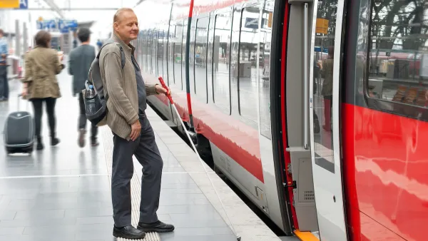
A mobile app helps transit riders with vision impairment plan trips more easily, interpreting signage and incorporating scheduling information. As Maylin Tu writes in Next City, the app was developed by Spain-based NaviLens and “uses codes posted at bus stops or in train stations to provide real-time navigation via audio and haptic (vibration) cues, directing the user from the elevator in a train station, for example, to a nearby bus stop.” Agencies including the New York City MTA have adopted the system. Last year, Vancouver’s TransLink agency launched a six-month pilot program at 16 stops to evaluate the effectiveness of the NaviLens system.
Like other accessibility features, designing public facilities for people with vision impairments can benefit other groups as well. “To improve wayfinding, [accessibility consultant Richard Marion] recommends that transit agencies focus on consistent and high-contrast signage across a region, so that people with some sight loss can easily distinguish between a no parking sign and a bus stop, for example, even if they don’t read braille. Making bus stops easy to identify would be helpful for wayfinding in general.”
FULL STORY: An App That Helps Riders With Vision Loss Navigate Complex Transit Systems


How to Improve Transit Accessibility
Over 13 million Americans face mobility challenges that limit their travel experience.

Website Streamlines Michigan Transit Information
The tool is designed to help people with disabilities navigate the state’s complex public transit network.
How Car Dependency Impacts People With Disabilities
People who are physically unable to drive can benefit from effective public transit systems and accessible, mixed-use neighborhoods.
National Parks Layoffs Will Cause Communities to Lose Billions
Thousands of essential park workers were laid off this week, just before the busy spring break season.

Retro-silient?: America’s First “Eco-burb,” The Woodlands Turns 50
A master-planned community north of Houston offers lessons on green infrastructure and resilient design, but falls short of its founder’s lofty affordability and walkability goals.

Delivering for America Plan Will Downgrade Mail Service in at Least 49.5 Percent of Zip Codes
Republican and Democrat lawmakers criticize the plan for its disproportionate negative impact on rural communities.

Test News Post 1
This is a summary

Test News Headline 46
Test for the image on the front page.

Balancing Bombs and Butterflies: How the National Guard Protects a Rare Species
The National Guard at Fort Indiantown Gap uses GIS technology and land management strategies to balance military training with conservation efforts, ensuring the survival of the rare eastern regal fritillary butterfly.
Urban Design for Planners 1: Software Tools
This six-course series explores essential urban design concepts using open source software and equips planners with the tools they need to participate fully in the urban design process.
Planning for Universal Design
Learn the tools for implementing Universal Design in planning regulations.
EMC Planning Group, Inc.
Planetizen
Planetizen
Mpact (formerly Rail~Volution)
Great Falls Development Authority, Inc.
HUDs Office of Policy Development and Research
NYU Wagner Graduate School of Public Service